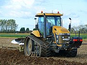
ਤਸਵੀਰ:Following the plough 3 - geograph.org.uk - 1019422.jpg
ਸਫ਼ਾ ਸਮੱਗਰੀ ਹੋਰ ਭਾਸ਼ਾਵਾਂ ਵਿੱਚ ਸਹਾਇਕ ਨਹੀ ਹੈ।
ਦਿੱਖ
ਵਿਕੀਪੀਡੀਆ, ਇੱਕ ਅਜ਼ਾਦ ਗਿਆਨਕੋਸ਼ ਤੋਂ
Following_the_plough_3_-_geograph.org.uk_-_1019422.jpg (640 × 557 ਪਿਕਸਲ, ਫ਼ਾਈਲ ਅਕਾਰ: 123 KB, MIME ਕਿਸਮ: image/jpeg)
ਇਹ ਫ਼ਾਈਲ Wikimedia Commons ਦੀ ਹੈ ਅਤੇ ਹੋਰ ਪਰਿਯੋਜਨਾਵਾਂ ਵਿੱਚ ਵੀ ਵਰਤੀ ਜਾ ਸਕਦੀ ਹੈ । ਇਸ ਫ਼ਾਈਲ ਦੇ ਵੇਰਵਾ ਸਫ਼ੇ ਵਿੱਚ ਮੌਜੂਦ ਵੇਰਵਾ ਹੇਠ ਦਿਸ ਰਿਹਾ ਹੈ।
| ਵੇਰਵਾFollowing the plough 3 - geograph.org.uk - 1019422.jpg |
English: "Following the plough" near to Leverton Lucasgate, Lincolnshire, Great Britain. A fine October sight! The Caterpillar Challenger tractor leads a procession of gulls across this field between the old and new Sea Banks near Leverton Lucasgate. Beyond the scene, by the windbreak trees is a pile of beet and an elevator used to get the crop into the lorries. |
||
| ਮਿਤੀ | |||
| ਸਰੋਤ | From geograph.org.uk | ||
| ਲਿਖਾਰੀ | Jonathan Billinger | ||
| ਇਜਾਜ਼ਤ (ਇਸ ਫ਼ਾਈਲ ਦੀ ਮੁੜਵਰਤੋਂ ਕਰੋ) |
This file is licensed under the Creative Commons Attribution-Share Alike 2.0 Generic license. ਐਟਰੀਬਿਊਸ਼ਨ: Jonathan Billinger
|
||
| Other versions |
|
||
| ਐਟਰੀਬਿਊਸ਼ਨ (required by the license) InfoField | Jonathan Billinger / Following the plough 3 / | ||
InfoField | Jonathan Billinger / Following the plough 3 |
| Camera location | 52° 59′ 53.84″ N, 0° 07′ 41.39″ E | View this and other nearby images on: OpenStreetMap |
|---|
| Object location | 52° 59′ 59″ N, 0° 07′ 29″ E | View this and other nearby images on: OpenStreetMap |
|---|
ਸੁਰਖੀ
Add a one-line explanation of what this file represents
Items portrayed in this file
ਚਿਤਰਨ
\u0a32\u0a47\u0a16\u0a15 \u0a28\u0a3e\u0a02 \u0a38\u0a1f\u0a30\u0a3f\u0a70\u0a17<\/a>"}},"text\/plain":{"pa":{"":"\u0a32\u0a47\u0a16\u0a15 \u0a28\u0a3e\u0a02 \u0a38\u0a1f\u0a30\u0a3f\u0a70\u0a17"}}},"{\"value\":\"Jonathan Billinger\",\"type\":\"string\"}":{"text\/html":{"pa":{"P2093":"Jonathan Billinger"}},"text\/plain":{"pa":{"P2093":"Jonathan Billinger"}}},"{\"value\":{\"entity-type\":\"property\",\"numeric-id\":3831,\"id\":\"P3831\"},\"type\":\"wikibase-entityid\"}":{"text\/html":{"pa":{"":"object has role<\/a>\u00a0\u0a05\u0a70\u0a17\u0a30\u0a47\u0a1c\u0a3c\u0a40<\/sup>"}},"text\/plain":{"pa":{"":"object has role"}}},"{\"value\":{\"entity-type\":\"item\",\"numeric-id\":33231,\"id\":\"Q33231\"},\"type\":\"wikibase-entityid\"}":{"text\/html":{"pa":{"P3831":"\u0a2b\u0a3c\u0a4b\u0a1f\u0a4b\u0a17\u0a4d\u0a30\u0a3e\u0a2b\u0a3c\u0a30<\/a>"}},"text\/plain":{"pa":{"P3831":"\u0a2b\u0a3c\u0a4b\u0a1f\u0a4b\u0a17\u0a4d\u0a30\u0a3e\u0a2b\u0a3c\u0a30"}}},"{\"value\":{\"entity-type\":\"property\",\"numeric-id\":2699,\"id\":\"P2699\"},\"type\":\"wikibase-entityid\"}":{"text\/html":{"pa":{"":"URL<\/a>\u00a0\u0a05\u0a70\u0a17\u0a30\u0a47\u0a1c\u0a3c\u0a40<\/sup>"}},"text\/plain":{"pa":{"":"URL"}}},"{\"value\":\"https:\\\/\\\/www.geograph.org.uk\\\/profile\\\/8569\",\"type\":\"string\"}":{"text\/html":{"pa":{"P2699":"https:\/\/www.geograph.org.uk\/profile\/8569<\/a>"}},"text\/plain":{"pa":{"P2699":"https:\/\/www.geograph.org.uk\/profile\/8569"}}}}" class="wbmi-entityview-statementsGroup wbmi-entityview-statementsGroup-P170 oo-ui-layout oo-ui-panelLayout oo-ui-panelLayout-framed">
creator ਅੰਗਰੇਜ਼ੀ
some value
copyrighted<\/a>\u00a0\u0a05\u0a70\u0a17\u0a30\u0a47\u0a1c\u0a3c\u0a40<\/sup>"}},"text\/plain":{"pa":{"P6216":"copyrighted"}}}}" class="wbmi-entityview-statementsGroup wbmi-entityview-statementsGroup-P6216 oo-ui-layout oo-ui-panelLayout oo-ui-panelLayout-framed">
copyright status ਅੰਗਰੇਜ਼ੀ
copyrighted ਅੰਗਰੇਜ਼ੀ
Creative Commons Attribution-ShareAlike 2.0 Generic<\/a>\u00a0\u0a05\u0a70\u0a17\u0a30\u0a47\u0a1c\u0a3c\u0a40<\/sup>"}},"text\/plain":{"pa":{"P275":"Creative Commons Attribution-ShareAlike 2.0 Generic"}}}}" class="wbmi-entityview-statementsGroup wbmi-entityview-statementsGroup-P275 oo-ui-layout oo-ui-panelLayout oo-ui-panelLayout-framed">
22 ਅਕਤੂਬਰ 2008
file available on the internet<\/a>\u00a0\u0a05\u0a70\u0a17\u0a30\u0a47\u0a1c\u0a3c\u0a40<\/sup>"}},"text\/plain":{"pa":{"P7482":"file available on the internet"}}},"{\"value\":{\"entity-type\":\"property\",\"numeric-id\":7384,\"id\":\"P7384\"},\"type\":\"wikibase-entityid\"}":{"text\/html":{"pa":{"":"geograph.org.uk image ID<\/a>\u00a0\u0a05\u0a70\u0a17\u0a30\u0a47\u0a1c\u0a3c\u0a40<\/sup>"}},"text\/plain":{"pa":{"":"geograph.org.uk image ID"}}},"{\"value\":\"1019422\",\"type\":\"string\"}":{"text\/html":{"pa":{"P7384":"1019422<\/a>"}},"text\/plain":{"pa":{"P7384":"1019422"}}},"{\"value\":{\"entity-type\":\"property\",\"numeric-id\":137,\"id\":\"P137\"},\"type\":\"wikibase-entityid\"}":{"text\/html":{"pa":{"":"operator<\/a>\u00a0\u0a05\u0a70\u0a17\u0a30\u0a47\u0a1c\u0a3c\u0a40<\/sup>"}},"text\/plain":{"pa":{"":"operator"}}},"{\"value\":{\"entity-type\":\"item\",\"numeric-id\":1503119,\"id\":\"Q1503119\"},\"type\":\"wikibase-entityid\"}":{"text\/html":{"pa":{"P137":"Geograph Britain and Ireland<\/a>\u00a0\u0a05\u0a70\u0a17\u0a30\u0a47\u0a1c\u0a3c\u0a40<\/sup>"}},"text\/plain":{"pa":{"P137":"Geograph Britain and Ireland"}}},"{\"value\":{\"entity-type\":\"property\",\"numeric-id\":973,\"id\":\"P973\"},\"type\":\"wikibase-entityid\"}":{"text\/html":{"pa":{"":"\u0a24\u0a2b\u0a3c\u0a38\u0a40\u0a32 \u0a26\u0a3e \u0a2a\u0a24\u0a3e<\/a>"}},"text\/plain":{"pa":{"":"\u0a24\u0a2b\u0a3c\u0a38\u0a40\u0a32 \u0a26\u0a3e \u0a2a\u0a24\u0a3e"}}},"{\"value\":\"https:\\\/\\\/www.geograph.org.uk\\\/photo\\\/1019422\",\"type\":\"string\"}":{"text\/html":{"pa":{"P973":"https:\/\/www.geograph.org.uk\/photo\/1019422<\/a>"}},"text\/plain":{"pa":{"P973":"https:\/\/www.geograph.org.uk\/photo\/1019422"}}}}" class="wbmi-entityview-statementsGroup wbmi-entityview-statementsGroup-P7482 oo-ui-layout oo-ui-panelLayout oo-ui-panelLayout-framed">
source of file ਅੰਗਰੇਜ਼ੀ
file available on the internet ਅੰਗਰੇਜ਼ੀ
heading<\/a>\u00a0\u0a05\u0a70\u0a17\u0a30\u0a47\u0a1c\u0a3c\u0a40<\/sup>"}},"text\/plain":{"pa":{"":"heading"}}},"{\"value\":{\"amount\":\"+292\",\"unit\":\"http:\\\/\\\/www.wikidata.org\\\/entity\\\/Q28390\"},\"type\":\"quantity\"}":{"text\/html":{"pa":{"P7787":"292 \u0a21\u0a3f\u0a17\u0a30\u0a40<\/span>"}},"text\/plain":{"pa":{"P7787":"292 \u0a21\u0a3f\u0a17\u0a30\u0a40"}}}}" class="wbmi-entityview-statementsGroup wbmi-entityview-statementsGroup-P1259 oo-ui-layout oo-ui-panelLayout oo-ui-panelLayout-framed">
coordinates of the point of view ਅੰਗਰੇਜ਼ੀ
52°59'53.844"N, 0°7'41.394"E
heading<\/a>\u00a0\u0a05\u0a70\u0a17\u0a30\u0a47\u0a1c\u0a3c\u0a40<\/sup>"}},"text\/plain":{"pa":{"":"heading"}}},"{\"value\":{\"amount\":\"+292\",\"unit\":\"http:\\\/\\\/www.wikidata.org\\\/entity\\\/Q28390\"},\"type\":\"quantity\"}":{"text\/html":{"pa":{"P7787":"292 \u0a21\u0a3f\u0a17\u0a30\u0a40<\/span>"}},"text\/plain":{"pa":{"P7787":"292 \u0a21\u0a3f\u0a17\u0a30\u0a40"}}}}" class="wbmi-entityview-statementsGroup wbmi-entityview-statementsGroup-P9149 oo-ui-layout oo-ui-panelLayout oo-ui-panelLayout-framed">
coordinates of depicted place ਅੰਗਰੇਜ਼ੀ
52°59'59.10"N, 0°7'28.56"E
image/jpeg
ਫ਼ਾਈਲ ਦਾ ਅਤੀਤ
ਤਾਰੀਖ/ਸਮੇਂ ’ਤੇ ਕਲਿੱਕ ਕਰੋ ਤਾਂ ਉਸ ਸਮੇਂ ਦੀ ਫਾਈਲ ਪੇਸ਼ ਹੋ ਜਾਵੇਗੀ।
| ਮਿਤੀ/ਸਮਾਂ | ਨਮੂਨਾ | ਨਾਪ | ਵਰਤੋਂਕਾਰ | ਟਿੱਪਣੀ | |
|---|---|---|---|---|---|
| ਮੌਜੂਦਾ | 00:41, 12 ਜੂਨ 2010 | 640 × 557 (123 KB) | File Upload Bot (Magnus Manske) | == {{int:filedesc}} == {{Information |Description={{en|1=Following the plough 3, near to Leverton Lucasgate, Lincolnshire, Great Britain. A fine October sight!<br /> The tractor leads a procession of gulls across this field between the old and new Sea Ban |
ਫ਼ਾਈਲ ਦੀ ਵਰਤੋਂ
ਇਹ ਫਾਈਲ ਹੇਠਾਂ ਦਿੱਤਾ ਸਫ਼ਾ ਵਰਤਦਾ ਹੈ:
ਫ਼ਾਈਲ ਦੀ ਵਿਆਪਕ ਵਰਤੋਂ
ਇਸ ਫ਼ਾਈਲ ਨੂੰ ਹੋਰ ਹੇਠ ਲਿਖੇ ਵਿਕੀ ਵਰਤਦੇ ਹਨ:
- en.wikipedia.org ਉੱਤੇ ਵਰਤੋਂ
- id.wikipedia.org ਉੱਤੇ ਵਰਤੋਂ
- tr.wikipedia.org ਉੱਤੇ ਵਰਤੋਂ
ਮੈਟਾਡੈਟਾ
ਇਸ ਫ਼ਾਈਲ ਵਿੱਚ ਵਾਧੂ ਜਾਣਕਾਰੀਆਂ ਹਨ, ਜੋ ਸ਼ਾਇਦ ਉਸ ਕੈਮਰੇ ਜਾਂ ਸਕੈਨਰ ਦੀ ਦੇਣ ਹਨ ਜੋ ਇਸਨੂੰ ਬਣਾਉਣ ਲਈ ਵਰਤਿਆ ਗਿਆ। ਜੇ ਇਸ ਫ਼ਾਈਲ ਵਿੱਚ ਕੋਈ ਤਬਦੀਲੀ ਕੀਤੀ ਗਈ ਹੈ ਤਾਂ ਹੋ ਸਕਦਾ ਹੈ ਕੁਝ ਵੇਰਵੇ ਬਦਲੀ ਫ਼ਾਈਲ ਦਾ ਸਹੀ ਰੂਪਮਾਨ ਨਾ ਹੋਣ।
| _error | 0 |
|---|


