Size of this preview: 557 × 599 pixels. Other resolutions: 223 × 240 pixels | 446 × 480 pixels | 886 × 953 pixels.
Original file (886 × 953 pixels, file size: 1.52 MB, MIME type: image/png)
| This is a file from the Wikimedia Commons. Information from its description page there is shown below. Commons is a freely licensed media file repository. You can help. |
Summary
| Description |
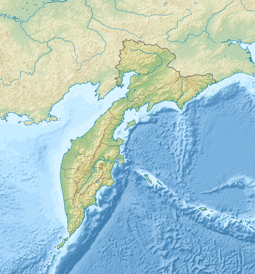
Русский: Физическая карта Камчатского края, Россия.
|
| Date | |
| Source |
|
| Author | Nzeemin |
| Other versions |
|
Licensing
I, the copyright holder of this work, hereby publish it under the following license:
This file is licensed under the Creative Commons Attribution-Share Alike 3.0 Unported license.
- You are free:
- to share – to copy, distribute and transmit the work
- to remix – to adapt the work
- Under the following conditions:
- attribution – You must give appropriate credit, provide a link to the license, and indicate if changes were made. You may do so in any reasonable manner, but not in any way that suggests the licensor endorses you or your use.
- share alike – If you remix, transform, or build upon the material, you must distribute your contributions under the same or compatible license as the original.
File history
Click on a date/time to view the file as it appeared at that time.
| Date/Time | Thumbnail | Dimensions | User | Comment | |
|---|---|---|---|---|---|
| current | 13:45, 19 February 2012 | 886 × 953 (1.52 MB) | Nzeemin | plus region bounds | |
| 06:19, 18 February 2012 | 886 × 953 (1.52 MB) | Nzeemin | corrected map coords | ||
| 05:43, 18 February 2012 | 886 × 953 (1.45 MB) | Nzeemin |
File usage
More than 100 pages use this file. The following list shows the first 100 pages that use this file only. A full list is available.
- 1952 Severo-Kurilsk earthquake
- 1959 Kamchatka earthquake
- 1997 Kamchatka earthquake
- 2013 Okhotsk Sea earthquake
- Akademia Nauk
- Akhtang
- Alney-Chashakondzha
- Anaun
- Asacha
- Atlasov (volcano)
- Bakening
- Barkhatnaya Sopka
- Belenkaya
- Bely (volcano)
- Bezymianny
- Bliznets
- Bolshoy Kekuknaysky
- Bolshoy Semyachik
- Cape Olyutor
- Cherpuk Group
- Chyorny Volcano
- Diky Greben
- Dzenzursky
- Eastern Range (Kamchatka)
- Eggella
- February 1923 Kamchatka earthquake
- Gamchen
- Golaya
- Gorely
- Gorny Institute
- Ichinsky
- Ilyinsky (volcano)
- Kambalny
- Kamen (volcano)
- Karymshina
- Karymsky (volcano)
- Karymsky Lake
- Kebeney
- Kell (volcano)
- Khangar
- Khuvkhoitun
- Kikhchik (river)
- Kikhpinych
- Kizimen
- Klyuchevskaya Sopka
- Komarov (volcano)
- Koryaksky
- Koshelev (volcano)
- Kostakan
- Krasheninnikov (volcano)
- Kronotsky
- Ksudach
- Lake Kronotskoye
- Lake Nerpichye (Kamchatka Krai)
- Ledyanaya
- Leutongey
- List of peninsulas
- Maly Payalpan
- Mashkovtsev (volcano)
- Mutnovsky
- Olyutor Gulf
- Opala (volcano)
- Operation Ivy Bells
- Ostry
- Otdelny
- Ozernoy
- Paren (river)
- Penzhina
- Plosky
- Shishel
- Snegovoy
- Titila
- Uksichan
- Valley of Geysers
- Vilyuchik
- Voyampolsky
- Vysoky (higher stratovolcano)
- Vysoky (lower stratovolcano)
- User:Ty654/List of earthquakes before 1900 exceeding magnitude 8+
- User:Ty654/List of earthquakes exceeding magnitude 8+
- User:Ty654/List of earthquakes from 1900-1949 exceeding magnitude 7+
- User:Ty654/List of earthquakes from 1920-1929 exceeding magnitude 6+
- User:Ty654/List of earthquakes from 1930-1939 exceeding magnitude 6+
- User:Ty654/List of earthquakes from 1940-1949 exceeding magnitude 6+
- User:Ty654/List of earthquakes from 1950-1954 exceeding magnitude 6+
- User:Ty654/List of earthquakes from 1950-1999 exceeding magnitude 7+
- User:Ty654/List of earthquakes from 1955-1959 exceeding magnitude 6+
- User:Ty654/List of earthquakes from 1960-1964 exceeding magnitude 6+
- User:Ty654/List of earthquakes from 1965-1969 exceeding magnitude 6+
- User:Ty654/List of earthquakes from 1970-1974 exceeding magnitude 6+
- User:Ty654/List of earthquakes from 1975-1979 exceeding magnitude 6+
- User:Ty654/List of earthquakes from 1980-1984 exceeding magnitude 6+
- User:Ty654/List of earthquakes from 1985-1989 exceeding magnitude 6+
- User:Ty654/List of earthquakes from 1990-1994 exceeding magnitude 6+
- User:Ty654/List of earthquakes from 1995-1999 exceeding magnitude 6+
- User:Ty654/List of earthquakes from 2000-2004 exceeding magnitude 6+
- User:Ty654/List of earthquakes from 2000-present exceeding magnitude 7+
- User:Ty654/List of earthquakes from 2005-2009 exceeding magnitude 6+
- User:Ty654/List of earthquakes from 2010-2014 exceeding magnitude 6+
- User:Ty654/List of earthquakes from 2015-2019 exceeding magnitude 6+
View more links to this file.
Global file usage
The following other wikis use this file:
- Usage on als.wikipedia.org
- Usage on ar.wikipedia.org
- Usage on azb.wikipedia.org
- Usage on az.wikipedia.org
- Şablon:Yer xəritəsi Rusiya Kamçatka diyarı
- Karaqinski adası
- Kronos körfəzi
- Avaçi körfəzi
- Avaça körfəzi
- Verxoturov adası
- Korf körfəzi
- Karaqin körfəzi
- Anapka körfəzi
- Kamçatski körfəzi
- Skrıtaya buxtası
- Natali buxtası
- Lavrov buxtası
- Yujnaya Qlubokaya buxtası
- Konus adası
- İviniçaman adası
- Vtoroy adası (Karaqin rayonu)
- Appapel
- Vtoroy adası (Penjin rayonu)
- Kraynı adası (Oxot dənizi)
- Zubçatı adası
- Rovnı adası
- Dobrjanski adası
- Kamni Çasovıe
- Obrıvıstı adası
- Kraşennikov adası
- Yenqalıçev adası
- Kayum (laqun)
- Boqoslov adası (Rusiya)
- Stariçkov adası
- Uzon vulkanı
- İlirqıtqın gölü
- Usage on be.wikipedia.org
View more global usage of this file.