File:'Ulster Covenant' mural, Thorndyke Street, Belfast - geograph.org.uk - 877908.jpg
Page contents not supported in other languages.
Appearance
Size of this preview: 561 × 599 pixels. Other resolutions: 225 × 240 pixels | 599 × 640 pixels.
Original file (599 × 640 pixels, file size: 621 KB, MIME type: image/jpeg)
This is a file from the Wikimedia Commons. Information from its description page there is shown below. Commons is a freely licensed media file repository. You can help. |
Summary
Description'Ulster Covenant' mural, Thorndyke Street, Belfast - geograph.org.uk - 877908.jpg |
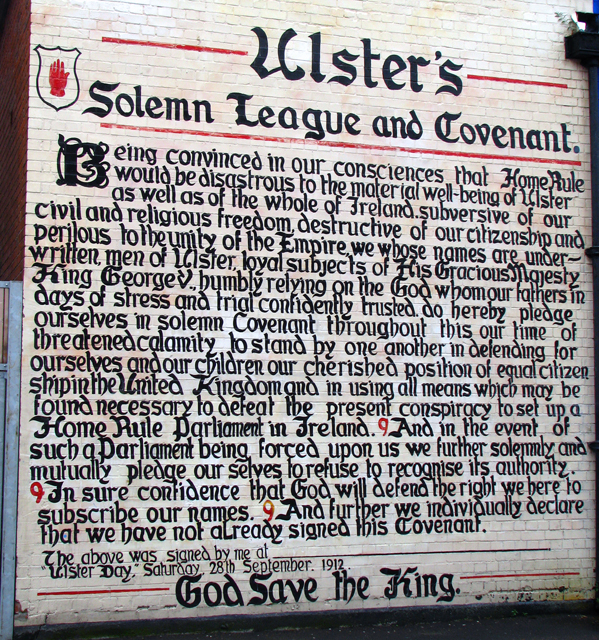
English: 'Ulster Covenant' mural, Thorndyke Street, Belfast. Mural reproducing the Ulster Covenant in Thorndyke Street, Belfast.
The Ulster Covenant was signed by just under half a million of men and women from Ulster, Ireland, on and before September 28, 1912, in protest of a Home Rule bill introduced by the British Government in that same year. Sir Edward Carson (see 693322 and 871614) was the first person to sign the Covenant at the Belfast City Hall. The signers were all unionists, who were against the establishment of an Irish parliament in Dublin. Some even signed in their own blood to show their dedication to the cause. The Ulster Covenant is immortalised in Rudyard Kipling's poem "Ulster 1912". See http://en.wikipedia.org/wiki/Ulster_Covenant for more information. |
Date | |
Source | From geograph.org.uk |
Author | Ross |
Camera location | 54° 35′ 43″ N, 5° 54′ 03″ W | View this and other nearby images on: OpenStreetMap |
---|
Object location | 54° 35′ 43″ N, 5° 54′ 03″ W | View this and other nearby images on: OpenStreetMap |
---|
Licensing
This image was taken from the Geograph project collection. See this photograph's page on the Geograph website for the photographer's contact details. The copyright on this image is owned by Ross and is licensed for reuse under the Creative Commons Attribution-ShareAlike 2.0 license.
|
This file is licensed under the Creative Commons Attribution-Share Alike 2.0 Generic license.
Attribution: Ross
- You are free:
- to share – to copy, distribute and transmit the work
- to remix – to adapt the work
- Under the following conditions:
- attribution – You must give appropriate credit, provide a link to the license, and indicate if changes were made. You may do so in any reasonable manner, but not in any way that suggests the licensor endorses you or your use.
- share alike – If you remix, transform, or build upon the material, you must distribute your contributions under the same or compatible license as the original.
Captions
Add a one-line explanation of what this file represents
Items portrayed in this file
depicts
object has role<\/a>"}},"text\/plain":{"en":{"":"object has role"}}},"{\"value\":{\"entity-type\":\"item\",\"numeric-id\":33231,\"id\":\"Q33231\"},\"type\":\"wikibase-entityid\"}":{"text\/html":{"en":{"P3831":"photographer<\/a>"}},"text\/plain":{"en":{"P3831":"photographer"}}},"{\"value\":{\"entity-type\":\"property\",\"numeric-id\":2699,\"id\":\"P2699\"},\"type\":\"wikibase-entityid\"}":{"text\/html":{"en":{"":"URL<\/a>"}},"text\/plain":{"en":{"":"URL"}}},"{\"value\":\"https:\\\/\\\/www.geograph.org.uk\\\/profile\\\/12869\",\"type\":\"string\"}":{"text\/html":{"en":{"P2699":"https:\/\/www.geograph.org.uk\/profile\/12869<\/a>"}},"text\/plain":{"en":{"P2699":"https:\/\/www.geograph.org.uk\/profile\/12869"}}},"{\"value\":{\"entity-type\":\"property\",\"numeric-id\":2093,\"id\":\"P2093\"},\"type\":\"wikibase-entityid\"}":{"text\/html":{"en":{"":"author name string<\/a>"}},"text\/plain":{"en":{"":"author name string"}}},"{\"value\":\"Ross\",\"type\":\"string\"}":{"text\/html":{"en":{"P2093":"Ross"}},"text\/plain":{"en":{"P2093":"Ross"}}}}" class="wbmi-entityview-statementsGroup wbmi-entityview-statementsGroup-P170 oo-ui-layout oo-ui-panelLayout oo-ui-panelLayout-framed">
copyrighted<\/a>"}},"text\/plain":{"en":{"P6216":"copyrighted"}}}}" class="wbmi-entityview-statementsGroup wbmi-entityview-statementsGroup-P6216 oo-ui-layout oo-ui-panelLayout oo-ui-panelLayout-framed">
Creative Commons Attribution-ShareAlike 2.0 Generic<\/a>"}},"text\/plain":{"en":{"P275":"Creative Commons Attribution-ShareAlike 2.0 Generic"}}}}" class="wbmi-entityview-statementsGroup wbmi-entityview-statementsGroup-P275 oo-ui-layout oo-ui-panelLayout oo-ui-panelLayout-framed">
10 July 2008
file available on the internet<\/a>"}},"text\/plain":{"en":{"P7482":"file available on the internet"}}},"{\"value\":{\"entity-type\":\"property\",\"numeric-id\":973,\"id\":\"P973\"},\"type\":\"wikibase-entityid\"}":{"text\/html":{"en":{"":"described at URL<\/a>"}},"text\/plain":{"en":{"":"described at URL"}}},"{\"value\":\"https:\\\/\\\/www.geograph.org.uk\\\/photo\\\/877908\",\"type\":\"string\"}":{"text\/html":{"en":{"P973":"https:\/\/www.geograph.org.uk\/photo\/877908<\/a>"}},"text\/plain":{"en":{"P973":"https:\/\/www.geograph.org.uk\/photo\/877908"}}},"{\"value\":{\"entity-type\":\"property\",\"numeric-id\":7384,\"id\":\"P7384\"},\"type\":\"wikibase-entityid\"}":{"text\/html":{"en":{"":"geograph.org.uk image ID<\/a>"}},"text\/plain":{"en":{"":"geograph.org.uk image ID"}}},"{\"value\":\"877908\",\"type\":\"string\"}":{"text\/html":{"en":{"P7384":"877908<\/a>"}},"text\/plain":{"en":{"P7384":"877908"}}},"{\"value\":{\"entity-type\":\"property\",\"numeric-id\":137,\"id\":\"P137\"},\"type\":\"wikibase-entityid\"}":{"text\/html":{"en":{"":"operator<\/a>"}},"text\/plain":{"en":{"":"operator"}}},"{\"value\":{\"entity-type\":\"item\",\"numeric-id\":1503119,\"id\":\"Q1503119\"},\"type\":\"wikibase-entityid\"}":{"text\/html":{"en":{"P137":"Geograph Britain and Ireland<\/a>"}},"text\/plain":{"en":{"P137":"Geograph Britain and Ireland"}}}}" class="wbmi-entityview-statementsGroup wbmi-entityview-statementsGroup-P7482 oo-ui-layout oo-ui-panelLayout oo-ui-panelLayout-framed">
heading<\/a>"}},"text\/plain":{"en":{"":"heading"}}},"{\"value\":{\"amount\":\"+22\",\"unit\":\"http:\\\/\\\/www.wikidata.org\\\/entity\\\/Q28390\"},\"type\":\"quantity\"}":{"text\/html":{"en":{"P7787":"22 degree<\/span>"}},"text\/plain":{"en":{"P7787":"22 degree"}}}}" class="wbmi-entityview-statementsGroup wbmi-entityview-statementsGroup-P1259 oo-ui-layout oo-ui-panelLayout oo-ui-panelLayout-framed">
54°35'42.54"N, 5°54'2.52"W
Canon PowerShot S5 IS<\/a>"}},"text\/plain":{"en":{"P4082":"Canon PowerShot S5 IS"}}}}" class="wbmi-entityview-statementsGroup wbmi-entityview-statementsGroup-P4082 oo-ui-layout oo-ui-panelLayout oo-ui-panelLayout-framed">
heading<\/a>"}},"text\/plain":{"en":{"":"heading"}}},"{\"value\":{\"amount\":\"+22\",\"unit\":\"http:\\\/\\\/www.wikidata.org\\\/entity\\\/Q28390\"},\"type\":\"quantity\"}":{"text\/html":{"en":{"P7787":"22 degree<\/span>"}},"text\/plain":{"en":{"P7787":"22 degree"}}}}" class="wbmi-entityview-statementsGroup wbmi-entityview-statementsGroup-P9149 oo-ui-layout oo-ui-panelLayout oo-ui-panelLayout-framed">
54°35'42.54"N, 5°54'2.52"W
image/jpeg
determination method<\/a>"}},"text\/plain":{"en":{"":"determination method"}}},"{\"value\":{\"entity-type\":\"item\",\"numeric-id\":13414952,\"id\":\"Q13414952\"},\"type\":\"wikibase-entityid\"}":{"text\/html":{"en":{"P459":"SHA-1<\/a>"}},"text\/plain":{"en":{"P459":"SHA-1"}}}}" class="wbmi-entityview-statementsGroup wbmi-entityview-statementsGroup-P4092 oo-ui-layout oo-ui-panelLayout oo-ui-panelLayout-framed">
c30689ce047313e9f4d87d3942fb3d0c440af1c4
635,663 byte
640 pixel
599 pixel
File history
Click on a date/time to view the file as it appeared at that time.
Date/Time | Thumbnail | Dimensions | User | Comment | |
---|---|---|---|---|---|
current | 08:08, 21 February 2011 | 599 × 640 (621 KB) | GeographBot | == {{int:filedesc}} == {{Information |description={{en|1='Ulster Covenant' mural, Thorndyke Street, Belfast Mural reproducing the Ulster Covenant in Thorndyke Street, Belfast. The Ulster Covenant was signed by just under half a million of men and women f |
File usage
The following pages on the English Wikipedia use this file (pages on other projects are not listed):
Global file usage
The following other wikis use this file:
- Usage on ga.wikipedia.org
Metadata
This file contains additional information, probably added from the digital camera or scanner used to create or digitize it.
If the file has been modified from its original state, some details may not fully reflect the modified file.
Camera manufacturer | Canon |
---|---|
Camera model | Canon PowerShot S5 IS |
Exposure time | 1/100 sec (0.01) |
F-number | f/5.6 |
ISO speed rating | 80 |
Date and time of data generation | 08:41, 10 July 2008 |
Lens focal length | 8.6 mm |
Orientation | Normal |
Horizontal resolution | 180 dpi |
Vertical resolution | 180 dpi |
Software used | Adobe Photoshop 7.0 |
File change date and time | 09:37, 10 July 2008 |
Y and C positioning | Centered |
Exif version | 2.2 |
Date and time of digitizing | 08:41, 10 July 2008 |
Meaning of each component |
|
Image compression mode | 5 |
Shutter speed | 6.65625 |
APEX aperture | 4.96875 |
Exposure bias | 0 |
Maximum land aperture | 3.34375 APEX (f/3.19) |
Metering mode | Center weighted average |
Flash | Flash did not fire, compulsory flash suppression |
Supported Flashpix version | 1 |
Color space | sRGB |
Focal plane X resolution | 14,485.207100592 |
Focal plane Y resolution | 14,506.666666667 |
Focal plane resolution unit | inches |
Sensing method | One-chip color area sensor |
File source | Digital still camera |