Tasmania
Template:Australia state or territory

Tasmania is an Australian island and state. It is 240 kilometres (150 mi) south of the continent, separated by Bass Strait. The state includes the island of Tasmania – the 26th largest island in the world – and the surrounding islands. The state has a population of 500,000 (as of December 2008[update]), of whom almost half reside in the greater Hobart precinct. Tasmania’s area is 68,401 square kilometres (26,410 sq mi), of which the main island covers 62,409 square kilometres (24,096 sq mi).[1]
Tasmania is promoted as the natural state, the "island of inspiration",[2] and A World Apart, Not A World Away owing to its large and relatively unspoiled natural environment. Almost 37% of Tasmania lies in reserves, national parks and World Heritage Sites.[3] The island is 364 kilometres (226 mi) long from northernmost to southernmost points, and 306 kilometres (190 mi) from west to east.
The state capital and largest city is Hobart, which encompasses the local government areas of City of Hobart, City of Glenorchy, and City of Clarence, while the satellite town of Kingston (part of the Municipality of Kingborough) is generally included in the Greater Hobart area. Other major population centres include Launceston in the north and Devonport and Burnie in the northwest.
The subantarctic Macquarie Island is also under the administration of the state, as part of the Huon Valley Council local government area.
Etymology
The state is named after Dutch explorer Abel Tasman, who made the first reported European sighting of the island on 24 November 1642. He named the island Anthony van Diemen's Land after his sponsor Anthony van Diemen, the Governor of the Dutch East Indies. The name was later shortened to Van Diemen's Land by the British. It was officially renamed in honour of its first European discoverer on 1 January 1856.[4] "Tassie" is a colloquial expression for the state, used for example in advertising for the Bass Strait ferry, Spirit of Tasmania.[5]
It was at one time known as Dervon, as mentioned in the The Jerilderie Letter written by the notorious Australian bushranger Ned Kelly.
History
Physical history

It is believed that the island was joined to the mainland of Australia until the end of the last glacial period approximately 10,000 years ago.
Much of the island is composed of Jurassic dolerite intrusions (upwellings of magma) through other rock types, sometimes forming large columnar joints. Tasmania has the world's largest areas of dolerite, with many distinctive mountains and cliffs formed from this rock type. The central plateau and the southeast portions of the island are mostly dolerite. Mount Wellington above Hobart is a good example, showing distinct columns known as the Organ Pipes. In the southwest, Precambrian quartzites are formed from very ancient sea sediments and form strikingly sharp ridges and ranges, such as Federation Peak or Frenchmans Cap. In the northeast and east, continental granites can be seen, such as at Freycinet, similar to coastal granites on mainland Australia. In the northwest and west, mineral-rich volcanic rock can be seen at Mount Read near Rosebery, or at Mount Lyell near Queenstown. Also present in the south and northwest is limestone with magnificent caves.
The quartzite and dolerite areas in the higher mountains show evidence of glaciation, and much of Australia's glaciated landscape is found on the Central Plateau and the Southwest. Cradle Mountain, another dolerite peak, for example, was a Nunatak. The combination of these different rock types offers incredible scenery, much of it distinct from any other region of the world.
Indigenous people

Tasmania was first inhabited by the Tasmanian Aborigines. Evidence indicates their presence in the region, later to become an island, at least 35,000 years ago.[6] Rising sea levels cut Tasmania off from mainland Australia about 10,000 years ago.
By the time of European contact, the Aboriginal people in Tasmania had nine major ethnic groups. At the time of British settlement in 1803, the indigenous population was estimated at between 5,000 and 10,000 people. Through the introduction of infectious diseases to which they had no immunity, war, and persecution, the population dwindled to 300 by 1833. Almost all of the indigenous population was relocated to Flinders Island by George Augustus Robinson.
A woman named Truganini (1812–76) is generally recognised as the last full-blooded Tasmanian Aborigine. Strong evidence suggests that the last survivor was another woman, Fanny Cochrane Smith, who was born at Wybalena and died in 1905.[7]
European arrival

The first reported sighting of Tasmania by a European was on 24 November 1642, by the Dutch explorer Abel Tasman. Tasman landed at today's Blackman's Bay. In 1773 Tobias Furneaux was the first Englishman to land in Tasmania at Adventure Bay. A French expedition led by Marc-Joseph Marion du Fresne also landed at Blackman's Bay in 1772. Captain James Cook landed at Adventure Bay in 1777 - with young William Bligh aboard. William Bligh returned in 1788 (H.M.S. Bounty) and again in 1792 (H.M.S Providence, with young Matthew Flinders aboard. Numerous other Europeans made landfalls, adding a colourful array to the names of topographical features. Matthew Flinders and George Bass first proved Tasmania to be an island in 1798-99.[8]
The first settling of Tasmania was by the British at Risdon Cove on the eastern bank of the Derwent estuary in 1803, by a small party sent from Sydney, under Lt. John Bowen for the purpose of preventing the French from claiming the island. An alternative settlement was established by Captain David Collins 5 kilometres (3.1 mi) to the south in 1804 in Sullivans Cove on the western side of the Derwent, where fresh water was more plentiful. The latter settlement became known as Hobart Town or Hobarton, later shortened to Hobart, after the British Colonial Secretary of the time, Lord Hobart. The settlement at Risdon was later abandoned.
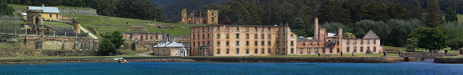
The early settlers were mostly convicts and their military guards, with the task of developing agriculture and other industries. Numerous other convict-based settlements were made in Van Diemen's Land, including secondary prisons, such as the particularly harsh penal colonies at Port Arthur in the southeast and Macquarie Harbour on the West Coast. In the fifty years from 1803 to 1853 around 75,000 convicts were transported to Tasmania.[9]
Van Diemen's Land was proclaimed a separate colony from New South Wales, with its own judicial establishment and Legislative Council, on 3 December 1825.
Colony of Tasmania
The Colony of Tasmania (more commonly referred to simply as "Tasmania") was a British colony that existed on the island of Tasmania from 1856 until 1901, when it federated together with the five other Australian colonies to form the Commonwealth of Australia. The possibility of the colony was established when the Westminster Parliament passed the Australian Colonies Government Act 1850, granting the right of legislative power to each of the six Australian colonies. The Legislative Council of Van Diemen's Land drafted a new constitution which they passed in 1854, and it was given Royal Assent by Queen Victoria in 1855. Later in that year the Privy Council approved the colony changing its name from "Van Diemen's Land" to "Tasmania", and in 1856, the newly elected bicameral parliament sat for the first time, establishing Tasmania as a self-governing colony of the British Empire.
The Colony suffered from economic fluctuations, but for the most part was prosperous, experiencing steady growth. With few external threats and strong trade links with the Empire, the Colony of Tasmania enjoyed many fruitful periods in the late 19th century, becoming a world-centre of shipbuilding. It raised a local defence force which eventually played a significant role in the Second Boer War in South Africa, and Tasmanian soldiers in that conflict won the first two Victoria Crosses won by Australians. Tasmanians voted in favour of federation with the largest majority of all the Australian colonies, and on 1 January 1901, the Colony of Tasmania, became the Australian state of Tasmania.
Recent history
The state was badly affected by the 1967 Tasmanian fires, in which there was major loss of life and property. In the 1970s, the state government announced plans to flood environmentally significant Lake Pedder. The collapse of the Tasman Bridge when struck by the bulk ore carrier MV Lake Illawarra in 1975 made crossing the Derwent River at Hobart almost impossible. National and international attention surrounded the campaign against the Franklin Dam in the early 1980s. This contributed to the start of the Green movement. On 28 April 1996 in the incident now known as the Port Arthur massacre, lone gunman Martin Bryant shot and killed 35 people (including tourists and residents) and injured 21 others. The use of firearms was immediately reviewed, and new gun ownership laws were adopted nationwide, with Tasmania's law one of the strictest in Australia. In April 2006, the Beaconsfield Mine collapse was triggered by a small earthquake. One person was killed and two others were trapped underground for 14 days. The Tasmanian community has for some time been divided over the issue of the proposed Bell Bay Pulp Mill to be built in the Tamar Valley. Proponents argue that jobs will be created while opponents argue that pollution will damage both the Bass strait fishing industry and local tourism.
Geography

Tasmania’s landmass of 68,401 square kilometres (26,410 sq mi) is located at 42°S 147°E / 42°S 147°E, right in the pathway of the notorious "Roaring Forties" wind that encircles the globe. The island is surrounded by the Indian and Pacific Oceans and separated from mainland Australia by Bass Strait.
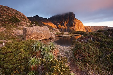
As the island has been volcanically inactive in recent geological times, Tasmania has many rounded smooth mountain ranges, making it the most mountainous state in Australia. The most mountainous region is the Central Highlands area, which covers most of the central western parts of the state. The Midlands located in the central east, is fairly flat, and is predominantly used for agriculture, although farming activity is scattered throughout the state. Tasmania's tallest mountain is Mount Ossa at 1,617 metres. The mountain lies in the heart of the world famous Cradle Mountain-Lake St Clair National Park.[10][11] Much of Tasmania is still densely forested, with the Southwest National Park and neighbouring areas holding some of the last temperate rain forests in the Southern Hemisphere

The Tarkine, located in island's far North West, is the largest temperate rainforest area in Australia covering approximately 3,800 square kilometres (1,500 sq mi).[12] With its rugged topography, Tasmania has a great number of rivers, with almost all dammed at some point to provide enough hydroelectricity for the entire state's needs. Most of the rivers begin in the Central Highlands and flow out to the coast. Tasmania's estuaries (although in many cases named rivers) are mainly situated around major population centres.
The Derwent River flows south and reaches the coast at Hobart, the Tamar River flows North from Launceston, the Mersey River also flows North to the North West coast at Devonport and the Franklin and Gordon Rivers flow west and meet the coast at Strahan. The South Esk River is the longest river in Tasmania. It starts in the mountains at Fingal and flows through Avoca, Evandale, Longford, Hadspen and finally Launceston. The river is dammed at Launceston's Trevallyn Dam and used for the city's hydroelectricity. Although most of the water is dammed at Lake Trevallyn, some flows on into the Cataract Gorge where it becomes a tributary to the Tamar River, and the outflow from the power station also joins the Tamar River downstream of Launceston.[13]
Climate
Tasmania has a cool temperate climate with four distinct seasons. Summer lasts from December to February when the average maximum sea temperature is 21 °C (70 °F) and inland areas around Launceston reach 24 °C (75 °F). Other inland areas are much cooler with Liawenee, located on the Central Plateau, one of the coldest places in Australia with temperatures in February ranging between 4 °C (39 °F) to 17 °C (63 °F). Autumn lasts between March and May and experiences changeable weather, where summer weather patterns gradually take on the shape of winter patterns.[14]

The winter months are between June and August and are generally the wettest and coolest months in the state, with most high lying areas receiving considerable snowfall. Winter maximums are 12 °C (54 °F) on average along coastal areas and 3 °C (37 °F) on the central plateau, thanks to a series of cold fronts from the Southern Ocean.[15] Spring is a season of transition, where winter weather patterns begin to take the shape of summer patterns. Although snowfall is still common up until October. Spring is generally the windiest time of the year with afternoon sea breezes starting to take effect on the coast.
Rainfall in Tasmania follows a complicated pattern rather analogous to that found on large continents at the same latitude in the northern hemisphere. On the western side rainfall increases from around 1,458 millimetres (57.4 in) at Strahan on the coast up to 2,690 millimetres (106 in) at Cradle Valley in the highlands.[16]
There is a strong winter maximum in rainfall: January and February typically averages between 30-40% the rainfall of July and August, though even in the driest months rain usually falls on every second day and the number of rainy days per year is much greater than on any part of the Australian mainland. Further east in the Lake Country, annual rainfall declines to around 900 millimetres (35 in), whilst in the Midlands, annual rainfall is as low as 450 millimetres (18 in) at Ross and generally below 600 millimetres (24 in). The eastern part of Tasmania has more evenly distributed rainfall than in the west, and most months receive very similar averages.
The densely populated northern coast is much drier than the western side, with annual rainfall ranging from 666 millimetres (26.2 in) in Launceston to 955 millimetres (37.6 in) in Burnie in the north west and 993 millimetres (39.1 in) in Scottsdale located further to the east.[17][18] Most rain falls in winter, and in summer the average can be as low as 31 millimetres (1.2 in) per month in Launceston. The east coast is wetter than the Midlands, with an average annual rainfall ranging from 775 millimetres (30.5 in) in St. Helens to around 640 millimetres (25 in) in Swansea.[19][20]
Here the rainfall is evenly distributed over the year but can be very erratic as heavy rainfalls from the warm Tasman Sea are quite frequent. Whereas a three-day fall of 125 millimetres (4.9 in) occurs only once every fifty years on the north coast, it occurs on average once every four or five years around Swansea and Bicheno, and on 7–8 June 1954, there were many falls as large as 230 millimetres (9.1 in) in two days in that area. The east coast is sometimes called the "sun coast" because of its sunny climate.[21]
Several sections of inland Tasmania, together with Flinders Island, were declared drought-affected areas by the state government in 2007.[22]
The highest recorded maximum temperature in Tasmania was 42.2 °C (108.0 °F) at Scamander on 30 January 2009, during the 2009 southeastern Australia heat wave. Tasmania's lowest recorded minimum temperature was −13.0 °C (8.6 °F) on 30 June 1983, at Butlers Gorge, Shannon, and Tarraleah.[23]
| City | Mean Min. Temp oC | Mean Max. Temp oC | No. Clear days | Rainfall (mm) |
|---|---|---|---|---|
| Hobart | 8.3 | 16.9 | 41 | 616[24] |
| Launceston | 7.2 | 18.4 | 50 | 666[25] |
| Devonport | 8.1 | 16.8 | 61 | 778[26] |
| Strahan | 7.9 | 16.5 | 41 | 1,458[27] |
Soils


Despite the presence of some quaternary glaciation, Tasmania's soils are not more fertile than those of mainland Australia, largely because most are severely leached and the areas with driest climate (thus least leaching) were unaffected by glaciation or alluvia derived therefrom. Most soils on the Bass Strait Islands, the east coast and western Tasmania are very infertile spodosols or psamments, with some even less fertile "lateritic podzolic soils" in the latter region. Most of these lands are thus not used for agriculture, but there is much productive forestry - which remains one of the state's major industries.
On the north coast, apart from some relatively fertile alluvial soils used for fruit growing, there are also deep red, easily workable soils known as "krasnozems" ("red land"). These soils are highly acidic and fix phosphate very effectively, but their extremely favourable physical properties make them extensively used for dairying, beef cattle and fodder crops.
The Midlands and the Lower Derwent present a different story from the rest of the state. Owing to a relatively dry climate and alkaline (mostly dolerite) parent material, these soils are relatively unleached and contain lime in the deeper subsoil. They are mostly classified as "prairie soils" or "brown earths" and bear some resemblance to the chernozems of Russia and North America, although they are much lower in available phosphorus and somewhat acidic in the surface levels. Their higher nutrient levels, however, allow them to support productive pasture, and large numbers of sheep are grazed in these regions. Some grain crops are also grown in the driest areas. In the alluvial areas of southeastern Tasmania, rich alluvial soils permit apples to be grown.
Ecology
Flora
Tasmania has extremely diverse vegetation, from the heavily grazed grassland of the dry Midlands to the tall evergreen eucalypt forest, alpine heathlands and large areas of cool temperate rainforests and moorlands in the rest of the state. Many flora species are unique to Tasmania, and some are related to species in South America and New Zealand through ancestors which grew on the super continent of Gondwana, 50 million years ago.
Tasmania is also home to some of the tallest and oldest trees of the world. While individual Huon pines are believed to be more than 2,000 years old, which is impressive by itself, a stand of male Huon pines at Mount Read has maintained itself by vegetative reproduction and is estimated to be more than 10,000 years old.[29] The tallest trees in Australia, more than 90 metres (300 ft) tall, are Eucalyptus regnans found in the Styx Valley . As these are still growing, there is hope they will surpass the tallest tree ever measured in the country, a mountain ash growing at Thorpdale, Victoria measuring more than 112 metres (367 ft) before it was felled in 1884.[30] Tasmania hosts the occurrence of certain endemic plant genera as well as plant genera of restricted distribution; an example of such a genus is Archeria.
Fauna
Thylacine/Tasmanian Tiger

The island of Tasmania was home to the Thylacine, a marsupial which resembled a wild dog. Known colloquially as the Tasmanian Tiger for the distinctive striping across its back, it became extinct in mainland Australia much earlier because of competition by the dingo, introduced in prehistoric times. Owing to persecution by farmers, government-funded bounty hunters and, in the final years, collectors for overseas museums, it appears to have been exterminated in Tasmania.
The Thylacine was the largest known carnivorous marsupial of modern times. The Thylacine was one of only two marsupials to have a pouch in both sexes (the other is the Water Opossum). The male Thylacine had a pouch that acted as a protective sheath, protecting the male's external reproductive organs while running through thick brush. The last known animal died in captivity in 1936. Many alleged sightings have since been recorded, none of them confirmed. The mature Thylacine ranged from 100 to 130 cm (39 to 51 in) long, plus a tail of around 50 to 65 cm (20 to 26 in).[31] The largest measured specimen was 290 cm (9.5 ft) from nose to tail. Adults stood about 60 cm (24 in) at the shoulder and weighed 20 to 30 kg (40 to 70 lb).[31] There was slight sexual dimorphism with the males being larger than females on average.[32]
Tasmanian Devil
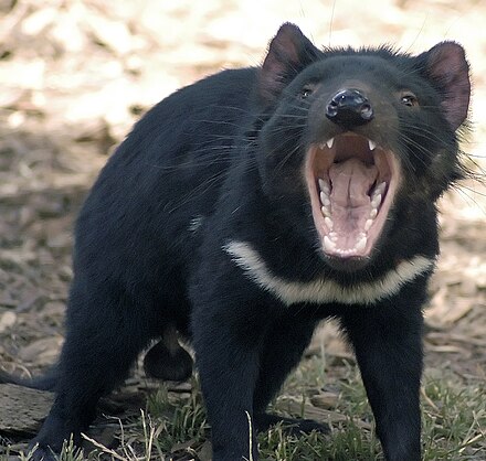
The Tasmanian Devil is a carnivorous marsupial found exclusively on the island of Tasmania. The size of a small dog but stocky and muscular, the Tasmanian Devil is characterised by black fur with white patches. It has a loud and disturbing screech-like growl, possesses a vicious temperament and is predominantly a scavenger. The Devil survived European settlement and was considered widespread and common throughout Tasmania until recently. As with a lot of wildlife, fast vehicles on roads are a problem for Tasmanian Devils, which are often killed while feeding on other road-killed animals such as wallabies. They eat everything including bone.
As of 2005, the Tasmanian Devil population has been reduced by up to 80% in parts of Tasmania by the devil facial tumour disease, which is gradually spreading throughout the island. It is believed the majority starved when the tumours spread to their mouths, and that the tumours are spread by fighting between devils over carcasses they feed on – typically, fighting devils will bite one another's faces. There is no known cure for the disease, and intensive research is underway to determine its cause. There is also a captive breeding program being undertaken by the Tasmanian government to establish a disease-free, genetically-diverse population of Tasmanian Devils outside Tasmania. This has been relatively successful so far.
Birds

Many birds of the Australian mainland and surrounding oceans are also found in Tasmania. Tasmania has 12 endemic bird species:
- 4 honeyeaters (family Meliphagidae) - the Yellow Wattlebird (world's largest honeyeater) and the Yellow-throated, Black-headed and Strong-billed Honeyeaters
- 3 Australo-Papuan warblers (family Acanthizidae) - the Tasmanian Thornbill, the Scrubtit and the Tasmanian Scrubwren
- 1 pardalote (family Pardalotidae) - the endangered Forty-spotted Pardalote
- 1 old-world flycatcher (family Muscicapidae) - the Dusky Robin
- 1 corvid (family Artamidae) - the Black Currawong
- 1 parrot (family Psittacidae) - the Green Rosella
- 1 rail (family Rallidae) - the Tasmanian Native-hen, Australia's only flightless land bird other than the giant ratites (Emu and Southern Cassowary).
The endemic Tasmanian Emu was exterminated in the mid-19th century. The Tasmanian Wedge-tailed Eagle is a threatened endemic subspecies.
Frogs

Tasmania is home to 11 species of frog. Three of these are found only in Tasmania, the Tasmanian Tree Frog (Litoria burrowsae), the Tasmanian Froglet (Crinia tasmaniensis) and the recently discovered Moss Froglet (Bryobatrachus nimbus). Of the 11 species that inhabit Tasmania all are native to Australia. Tasmania is home to the largest breeding population of Growling Grass Frogs (Litoria raniformis), a vulnerable species, which has declined over much of its range.
European Red Fox
On 20 June 2001, Tasmania formed a fox task force, now the Fox Eradication Branch, to eliminate the European red fox. Officials planned to spend up to AU$50 million on an eradication campaign, which has since been reduced. No foxes have been captured, poisoned or photographed with certainty in the Island state, although four carcasses have been recovered. Of these, one was claimed to be shot, and the other 3 presumed road-kills. The lack of an abundance of foxes, through low population densities, and fox-poisoning campaigns, has resulted in an abundance of denial of fox presence by the Tasmanian community. Established foxes in Tasmania could devastate native mammals, livestock, ground-nesting birds and native rodents. Experts estimate there are fewer than 30 million foxes on mainland Australia, having been introduced by European settlers.[33]
Since white settlement, about 28 native mammal species or subspecies have become extinct from the Australian mainland, the worst rate of continental extinction in the world. Red Foxes are known to be a significant contributing factor to this. Mainland extinctions or near-extinctions include the Eastern Barred Bandicoot, Eastern Quoll, and Tasmanian Pademelon (Thylogale billardierii); all still common in Tasmania. A member of the upper house, the Legislative Council member for Windermere Ivan Dean MLC has been publicly critical of the fox evidence used to obtain funding for a taxpayer funded Fox Eradication Branch of the Tasmanian D.P.I.P.W.E. Former Tasmanian Police Commander, Mr Dean, led a Police investigation into the alleged importation and release of foxes into Tasmania. The investigation did not uncover any evidence of illegal importation. He then raised the Tasmanian Fox issue in the Tasmanian Parliament on 17 April 2007.[34] In addition to the 4 carcasses, over 40 independently tested fox-DNA-confirmed scats have been located across Tasmania. Through Government review, Foxes are now confirmed to be in Tasmania.[35] Certain prominent Tasmanians [who?] including Dr David Obendorf have been calling for a Federal Police investigation into allegations that evidence has been planted and this is all part of an elaborate hoax to receive funding from the Commonwealth.[36]
Government
The form of the government of Tasmania is prescribed in its constitution, which dates from 1856, although it has been amended many times since then. Since 1901, Tasmania has been a state of the Commonwealth of Australia, and the Australian Constitution regulates its relationship with the Commonwealth and prescribes which powers each level of government enjoys.
Politics
Tasmania is a State in the Australian federation. Its relationship with the Federal Government and Parliament are regulated by the Australian Constitution. Tasmania is represented in the Senate by 12 senators, on an equal basis with all other states. In the House of Representatives Tasmania is entitled to five seats, which is the minimum guaranteed by the Constitution. The number of House of Representatives seats for each state is otherwise decided on the basis of their relative populations, and Tasmania has never qualified for five seats on that basis alone. Tasmania's House of Assembly and local government elections use a system of multi-seat proportional representation known as Hare-Clark.
| Composition of the Parliament of Tasmania | ||
|---|---|---|
| Political Party |
House of Assembly |
Legislative Council |
| ALP | 10 | 3 |
| Liberal | 10 | 1 |
| Greens | 5 | 0 |
| Independent | 0 | 11 |
| Source: Tasmanian Electoral Commission | ||
At the 2002 state election, the Labor Party won 14 of the 25 House seats. The Liberal Party saw their percentage of the vote decrease dramatically, and their representation in the Parliament fell to seven seats. The Greens won four seats, with over 18% of the popular vote, the highest proportion of any Green party in any parliament in the world.

On 23 February 2004, the Premier Jim Bacon announced his retirement, after being diagnosed with lung cancer. In his last months he opened a vigorous anti-smoking campaign which included many restrictions of where individuals could smoke, such as pubs. He died four months later. Bacon was succeeded by Paul Lennon, who, after leading the state for two years, went on to win the 2006 state election in his own right. Lennon resigned in 2008 and was succeeded by David Bartlett.
Tasmania has numerous relatively unspoiled, ecologically valuable regions. Proposals for local economic development have therefore been faced with strong requirements for environmental sensitivity, or outright opposition. In particular, proposals for hydroelectric power generation proved controversial in the late 20th century. In the 1970s, opposition to the construction of the Lake Pedder impoundment led to the formation of the world's first green party, the United Tasmania Group.[37]
In the early 1980s the state was again plunged into often bitter debate over the proposed Franklin River Dam. The anti-dam sentiment was shared by many Australians outside Tasmania and proved a factor in the election of the Hawke Labor government in 1983, which halted construction of the dam. Since the 1980s the environmental focus has shifted to old growth logging, which has proved a highly divisive issue. The Tasmania Together process recommended an end to clear felling in high conservation old growth forests by January 2003.
Demographics
The majority of the residents are of British descent.[38] As of 2008, Tasmania is the only state in Australia which has an above-replacement Total Fertility Rate. Tasmanian women are having an average of 2.24 children each.[39] This is also the highest TFR recorded in Tasmania after 1975.[40][41]
Economy

Tasmania's erratic economy was first experienced by colonists in the early 19th century.[citation needed] The reasons have been many and varied over the years. More recently the reasons have been attributed to: lack of federal infrastructure highway, lack of a gold rush, lack of open immigration initiatives, lack of population, decline in the wool and mineral economies, lack of early colonial initiatives, or lack of foreign investment. For the length of the history of Tasmania there has been a continuing exodus of youth to mainland Australia in order to seek employment opportunities.
Traditionally Tasmania's main industries have been: mining, including copper, zinc, tin, and iron; agriculture; forestry; and tourism. Significantly in the 1940s and 1950s there had been a Hydro-Industrialisation initiative embodied in the state by Hydro Tasmania. These all have had varying fortunes over the last century and more, involved in ebbs and flows of population moving in and away dependent upon the specific requirements of the dominant industries of the time.
There had been a decline in manufacturing during the 1990s, leading to a drain of some of the island's trained and experienced working population to mainland Australia. The major urban centres such as Melbourne and Sydney are popular destinations.
The state has a large number of food exporting sectors, including but not limited to seafood (for example, Atlantic salmon, abalone and crayfish).
Since 2001, Tasmania has experienced a positive turnaround. Favourable economic conditions throughout Australia, cheaper air fares and two new Spirit of Tasmania ferries have all contributed to what is now a booming tourism industry.
Today, a significant number of employed Tasmanians work for the government. Other major employers include the Federal Group, owner of several hotels and Tasmania's two casinos, and Gunns Limited, the state's biggest forestry company. In the late 1990s, many national companies based their call centres in the state after obtaining cheap access to broad-band fibre-optic connections.[citation needed]
Apparently the state's housing market was undervalued in the early part of 2000, and a large boom in the national housing market finally made Tasmanian housing prices rise dramatically. This has in part been attributed to increased levels of interstate[42] and overseas migration. A shortage of rental accommodation has caused problems for many of Tasmania's low income earners.
Small business is a large part of the community life and it is believed by many that the business environment in Tasmania is not an easy one to survive in. However there have been many success stories, such as International Catamarans, Moorilla Estate and Tassal.
Transport

Tasmania's main air carriers are Qantas and its subsidiary Jetstar, and Virgin Blue, which fly direct routes to Melbourne, Sydney, Brisbane, and Adelaide. Low cost airline Tiger Airways commenced services between Melbourne and Launceston in November 2007 and Hobart in January 2008. Major airports include Hobart International Airport (which, has not actually had a regular scheduled international passenger service since the 1990s) and Launceston Airport; the smaller airports, Burnie (Wynyard), serviced by Regional Express and Devonport, serviced by QantasLink have services to Melbourne.
The domestic sea route is serviced by Bass Strait passenger/vehicle ferries operated by the Tasmanian Government-owned TT-Line (Tasmania). From 1986 the Abel Tasman made six weekly overnight crossings between Devonport and Melbourne. It was replaced by the Spirit of Tasmania in 1993, which performed the same route and schedule. The most recent change was the 2002 replacement of the Spirit by two Superfast ferries - Spirit of Tasmania I and Spirit of Tasmania II — which brought the number of weekly overnight crossings up to fourteen, plus additional daylight crossings in peak times. In January 2004 a third ship, the slightly smaller Spirit of Tasmania III, started the Devonport to Sydney route. This service was axed by the Tasmanian Government in June 2006 quoting low passenger numbers. There is also a ferry service from Bridport, Tasmania to Flinders Island and Port Welshpool, Victoria.[43] Two container ships owned by Toll Shipping make daily crossings between Burnie and Melbourne. The port of Hobart also serves as a host to visiting cruise ships.

The state is also home to International Catamarans, a manufacturer of very high-speed aluminium vessels (commonly known as SeaCat) that regularly broke records when they were first launched. The state government tried using them on the Bass Strait run but eventually decided to discontinue the run because of concerns over viability and the suitability of the vessels for the extreme weather conditions sometimes experienced in the strait.
Tasmania, Hobart in particular, serves as Australia's chief sea link to Antarctica, with the Australian Antarctic Division located in Kingston. Hobart is also the home port of the French ship l'Astrolabe, which makes regular supply runs to the French Southern Territories near and in Antarctica. Hobart has the second deepest natural port in the world, second to only Rio de Janeiro in Brazil.
Within the state, the primary form of transport is by road. Since the 1980s, many of the state's highways have undergone regular upgrades. These include the Hobart Southern Outlet, Launceston Southern Outlet, Bass Highway reconstruction, and the Huon Highway. Public transport is provided by Metro Tasmania bus services.
Rail transport in Tasmania consists of narrow-gauge lines to all four major population centres and to mining and forestry operations on the west coast and in the northwest. Services are operated by TasRail, a Pacific National subsidiary. Regular passenger train services in the state ceased in 1977; the only trains are for freight, and there are tourist trains in specific areas, for example the West Coast Wilderness Railway. In 2005 there were concerns that the rail service was in so much trouble that it might stop for everything but cement haulage.
Culture
Cuisine
During colonial times typical English cuisine would have been standard in most areas of Tasmania. The arrival of immigrants and changing cultural patterns has meant Tasmania now has a wide range of restaurants. Scattered across Tasmania are many vineyards, and Tasmanian beer brands such as Boags and Cascade are known and sold on the mainland. King Island off the northwestern coast of Tasmania has a reputation for boutique cheeses and dairy products. Tasmanians are also consumers of seafood, such as Crayfish, Orange roughy and Salmon, both farmed and wild.
Events
In order to foster tourism, the state government encourages or supports several different annual events in and around the island. The best known of these would be the Sydney to Hobart Yacht Race, starting on Boxing Day in Sydney and usually arriving at Constitution Dock in Hobart around three to four days later, during the Taste of Tasmania, an annual food and wine festival.
Other events include the road rally Targa Tasmania which attracts world-class rally drivers and is staged all over the state, over five days. Rural or regional events include Agfest, a three-day agricultural show held at Carrick (just west of Launceston) in early May; and the Royal Hobart Show and Royal Launceston Show, both held in October annually. Music events held in Tasmania include the Falls Festival at Marion Bay (a Victoria event now held in both Victoria,and Tasmania on New Year's Eve), MS Fest is held in Launceston it helps raise money for those with multiple sclerosis and the Southern Roots Festival held in Hobart each Easter. A recent addition to the state has been the 10 Days on the Island arts festival.
Literature
Tasmania has a relatively small but growing literary culture. Notable titles include For the Term of His Natural Life by Marcus Clarke, The Sound of One Hand Clapping, Gould's Book of Fish by Richard Flanagan and The Year of Living Dangerously by Christopher Koch. The ‘Tasmanian genre’[clarification needed] of fiction includes children's books such as Tiger Tale by Marion and Steve Isham.
Music and performing arts
Tasmania has a varied musical scene, ranging from the Tasmanian Symphony Orchestra whose home is the Federation Concert Hall, to a substantial number of small bands, orchestras, string quintets, saxophone ensembles and individual artists who perform at a variety of venues around the state. Tasmania is also home to a vibrant community of composers including Constantine Koukias, Maria Grenfell and Don Kay, who is the patron of the Tasmanian Composers Collective,[44] the representative body for composers in Tasmania. Tasmania is also home to one of Australia's leading new music institutions, IHOS Music Theatre and Opera and gospel choirs, the Southern Gospel Choir. Death Metal band Psycroptic hails from Tasmania and are one of the most prominent Australian metal bands.[45] Respected noir-rock band The Paradise Motel[46] and eighties power-pop combo The Innocents[47] are also citizens. Apart from the Classical musical season and regular gigs across the state by a number of local and interstate groups two of the highlights of the musical year would be the Falls Festival held during the summer holidays and the Carols by Candlelight held in the weeks prior to Christmas.
The first season of The Mole was filmed and based mainly in Tasmania, with the final elimination taking place in the famous Port Arthur gaol.
Tasmanian cinema
Films set in Tasmania include The Tale of Ruby Rose, The Last Confession of Alexander Pearce and the recent feature; Van Diemen's Land. In all three, the Tasmanian landscape is an important element. The Last Confession of Alexander Pearce and Van Diemen's Land are both set during an episode of Tasmania's convict history.
Visual arts
The biennial Tasmanian Living Artists' Week is a ten-day state-wide festival for Tasmania's visual artists. The fourth festival in 2007 involved more than 1000 artists. Tasmania is home to two winners of the prestigious Archibald Prize – Jack Carington Smith in 1963 for a portrait of Professor James McAuleyand and Geoffrey Dyer in 2003 for his portrait of Richard Flanagan. Photographers Olegas Truchanas and Peter Dombrovskis are known for works that became iconic in the Lake Pedder and Franklin Dam conservation movements. English-born painter John Glover (1767–1849) is known for his paintings of Tasmanian landscapes.
Media
Television
Tasmania has had five broadcast television stations:
- ABC Tasmania. Produces nightly local news at 7pm. (digital & analogue) (callsign: ABT)
- SBS One (digital & analogue) (callsign: SBS)
- Southern Cross Television Tasmania (digital & analogue). Affiliate of Seven Network. (callsign: TNT).
- WIN Television Tasmania. (digital & analogue). Affiliate of Nine Network (callsign: TVT)
- Tasmania Digital Television. Receives Ten News At Five from ATV-10 in Melbourne. (digital only). Affiliate of Ten Network (callsign: TDT)
In addition, broadcasters operate digital multichannels:
- ABC2 (carried by ABT)
- ABC3 (carried by ABT)
- ABC News 24 (carried by ABT)
- SBS Two (carried by SBS)
- SBS HD (carried by SBS)
- One HD (carried by TDT)
- GO! (carried by TVT)
- WIN HD (carried by TVT)
- Southern Cross HD (carried by TNT)
- 7TWO (carried by TNT)
Sport

Sport is not only an important pastime in Tasmania, the state has produced several famous sportsmen and women and also hosted several major sporting events. The Tasmanian Tigers cricket team represents the state successfully (for example the Sheffield Shield in 2007) and plays its home games at the Bellerive Oval, Hobart; also the site of international cricket matches. Famous Tasmanian cricketers include David Boon and current Australian captain Ricky Ponting. Australian Rules Football is also popularly followed, with occasional discussion of a proposed Tasmanian team in the Australian Football League (AFL). Several AFL games have been played at the Aurora Stadium, York Park Launceston, including the Hawthorn Football Club. The stadium was the site of an infamous match between St Kilda and Fremantle which was controversially drawn after the umpires failed to hear the final siren.
Association Football (Soccer) is played throughout the state, with discussion of a Tasmanian Hyundai A-league Club building on the existing Southern Premier League and the Northern Premier League. Tasmania hosts the Moorilla International tennis tournament as part of the lead up to the Australian Open and is played at the Hobart International Tennis Centre, Hobart. The Sydney to Hobart Yacht Race run every year between Boxing Day and New Year since 1945, finishes in Hobart.
While some of the other sports played and barracked for have grown in popularity, others have declined. For example in basketball Tasmania has not been represented in the National Basketball League since the demise of the Hobart Devils in 1996.
Places in Tasmania


|
Islands:
Lakes: |
Significant bridges:
Beaches: |
Main highways: |
Rivers: |
Mountains:
Regions: |
Prominent Tasmanians
Notable people from Tasmania include:
- Crown Princess Mary of Denmark (Mary Donaldson)
- Joseph Lyons, former Prime Minister of Australia
- his wife Dame Enid Lyons, the first woman member of the House of Representatives
- Elizabeth Blackburn, first woman from Australia to win a Nobel Prize
- author Richard Flanagan
- author Christopher Koch
- actor Errol Flynn
- actor Simon Baker, star of The Mentalist
- actress Rachael Taylor
- dancer and choreographer Graeme Murphy
- composer Peter Sculthorpe
- Anglican Archbishop of Brisbane and Primate of Australia Phillip Aspinall
- world champion woodchopper David Foster
- cricketer Ricky Ponting
- Australian cricketer - David Boon
- Truganini, last surviving full-blooded Tasmanian Aborigine
- V8 Supercar driver John Bowe (1995 champion)
- V8 Supercar driver Marcos Ambrose (2003-2004 champion)
- F. Matthias Alexander (1869–1955) - originator of the Alexander Technique
- Michelle G. Craske, Ph.D. - clinical researcher, author, therapist, and professor
- John Gellibrand, Founder of Legacy
- Cyclist Luke Ockerby
- Cyclist Richie Porte
- drummer Dave Haley from technical death metal band Psycroptic and black metal band Ruins (metal band)
- Bob Clifford - Owner and founder of Incat
- Alex Pope of Ruins (metal band) and formerly of Sea Scouts (band)
See also
- Domestic partnership in Tasmania
- Grand Duchy of Avram
- List of schools in Tasmania
- Protected areas of Tasmania
- University of Tasmania
References
- ^ 'Facts About Tasmania' Brand Tasmania.com. Retrieved 15 June 2009.
- ^ "Tasmania - Island of Inspiration". Archived from the original on 25 January 2008. Retrieved 31 December 2007.
- ^ "Complete National Parks and Reserves Listings". Parks and Wildlife Service. 10 November 2006. Retrieved 30 November 2006.
- ^ 'Select chronology of renaming' Parliament of Tasmania http://www.parliament.tas.gov.au/php/BecomingTasmania/BTAppend2.htm Retrieved 15 June 2009.
- ^ 'Tassie Journeys' Spirit of Tasmania Retrieved 24 June 2009. [dead link]
- ^ "Tasmanian Aboriginal People and History". Aboriginal Art Online. Retrieved 29 March 2010.
- ^ Smith, Fanny Cochrane (1834 - 1905) Australian Dictionary of Biography Online
- ^ The Early History of Tasmania, R.W.Giblin 1928
- ^ "Convicts and the British colonies in Australia". Culture.gov.au.
- ^ Cite error: The named reference
heightwas invoked but never defined (see the help page). - ^ 'Mt. Ossa, Tasmania' The Interactive Tour of Tasmania http://tourtasmania.com/content.php?id=ossa Retrieved 15 June 2009.
- ^ 'About the Tarkine' Tarkine: Australia's Largest Temperate Rain forest Retrieved 15 June 2009.
- ^ 'Statistics - Tasmania, 2006', Australian Bureau of Statistics. Retrieved 25 June 2009.
- ^ "Climate of Launceston". Australian BOM. Retrieved 1 January 2009.
- ^ "Tasmania Climate". World 66. Retrieved 1 January 2009.
- ^ "Cradle Valley Climate". Australian Government Bureau of Meteorology. Retrieved 1 January 2009.
- ^ "Burnie Climate". Australian Government Bureau of Meteorology. Retrieved 1 January 2009.
- ^ "Scottsdale Climate". Australian Government Bureau of Meteorology. Retrieved 1 January 2009.
- ^ "St Helens Climate". Australian Government Bureau of Meteorology. Retrieved 1 January 2009.
- ^ "Swansea Climate". Australian Government Bureau of Meteorology. Retrieved 1 January 2009.
- ^ "Climate of Tasmania". T Change. Retrieved 1 January 2009.
- ^ "Midlands Drought area" (PDF). Tasmanian Government. Retrieved 1 January 2009.
- ^ "Rainfall and Temperature Records: National" (PDF). Bureau of Meteorology. Retrieved 14 November 2009.
- ^ "Hobart Climate Statistics". Australian Government Bureau of Meteorology. Retrieved 1 January 2009.
- ^ "Launceston Climate Statistics". Australian Government Bureau of Meteorology. Retrieved 1 January 2009.
- ^ "Devonport Climate Statistics". Australian Government Bureau of Meteorology. Retrieved 1 January 2009.
- ^ "Strahan Climate Statistics". Australian Government Bureau of Meteorology. Retrieved 1 January 2009.
- ^ "World Heritage Values - Flora". Parks and Wildlife Service Tasmania. Retrieved 20 February 2010.
- ^ "Native Conifers of Western Tasmania". Department of Primary Industries and Water. 20 September 2007. Retrieved 11 January 2008.
- ^ "Australia's Biggest, Tallest and Oldest Trees". International Society of Arboriculture Australia Chapter. 2004. Retrieved 11 January 2008.
- ^ a b Sally Bryant and Jean Jackson Threatened Species Unit, Parks and Wildlife Service, Tasmania (1999). Tasmania's Threatened Fauna Handbook (PDF). Bryant and Jackson. pp. 190–193. ISBN 0-7246-6223-5.
{{cite book}}: CS1 maint: multiple names: authors list (link) - ^ Menna Jones (1997-12). "Character displacement in Australian dasyurid carnivores: size relationships and prey size patterns". Ecology. Ecological Society of America. Retrieved 27 November 2006.
{{cite journal}}: Check date values in:|date=(help) - ^ Mercer, Phil (24 September 2007) 'Fox invasion fear grips Tasmania', BBC NEWS
- ^ Tasmanian Parliament Legislative Council Part 1- Pages 1–61 Hansard 17 April 2007[dead link]
- ^ "Foxes officially confirmed in Tasmania". Australian Broadcasting Corporation. 24 December 2009. Retrieved 2 April 2010.
- ^ "The Federal Police should be asked to investigate". Tasmanian Times. Retrieved 2 April 2010.
- ^ Davies, Lynn (2006). "Lake Pedder". Centre for Tasmanian Historical Studies. Retrieved 6 March 2010.
- ^ "Tasmania (island and state, Australia)". Encyclopædia Britannica Online.
- ^ "Australia had baby boom in 2007: ABS". The Age. Australia. Retrieved 2 April 2010.
- ^ "3301.0 - Births, Australia, 2008". ABS. 19 January 2010. Retrieved 2 April 2010.
- ^ Vaughan, Joanna (11 November 2009). "Highest birth rate in 38 years". The Australian. Retrieved 2 April 2010.
- ^ ABC Television News (Tasmania), 7 p.m. Friday, 27/1/06
- ^ 'Main', Southern Shipping Company, Retrieved 15 June 2009.
- ^ 'Don Kay', Tasmanian Composers Collective, Retrieved 15 June 2009.
- ^ "PSYCROPTIC: Rise Above". www.themetalforge.com. Retrieved 6 March 2010.
- ^ 'The Paradise Motel' last.fm http://www.last.fm/music/The+Paradise+Motel Retrieved 15 June 2009.
- ^ "Beathoven and The Innocents - Official Web site". The Innocents. Retrieved 2 April 2010.
Further reading
- Alexander, Alison (editor) (2005)The Companion to Tasmanian History Centre for Tasmanian Historical Studies, University of Tasmania, Hobart. ISBN 1-86295-223-X.
- Robson, L.L. (1983) A History of Tasmania. Volume I. Van Diemen's Land From the Earliest Times to 1855 Melbourne, Oxford University Press. ISBN 0-19-554364-5.
- Robson, L.L. (1991) A History of Tasmania. Volume II. Colony and State From 1856 to the 1980s Melbourne, Oxford University Press. ISBN 0-19-553031-4.
External links
- Tasmania Online - the main State Government website
- Discover Tasmania - official tourism website
| States |  | ||||||||
|---|---|---|---|---|---|---|---|---|---|
| Territories |
| ||||||||
(1) Sovereignty recognised only by France, New Zealand, Norway, and the United Kingdom. (2) Co-mandate with New Zealand and the United Kingdom. | |||||||||