Ninety Mile Beach, Victoria

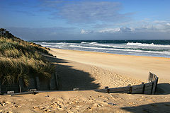
The Ninety Mile Beach is a sandy stretch of south-eastern coastline of Victoria, Australia which separates the Gippsland Lakes region from Bass Strait.
It is believed to be the third longest uninterrupted beach in the world (behind Praia do Cassino on the Brazilian southern coast and Padre Island on the US Gulf Coast) — just over 151 kilometres (94 miles) running northeastward from a spit near Port Albert to the man-made channel at Lakes Entrance, passing the coastal towns of Woodside, Seaspray, Golden Beach, and Loch Sport. For the northern part of its route the beach runs along a sandbar on what amounts to a series of tidal islands and behind which are several large lakes and numerous shallow littoral lagoons. The area comprises the Gippsland Lakes Coastal Park.
The beach's length ensures that the waves break too close to the beach for good surfing, and there are strong rip currents and cross-currents making the conditions somewhat hazardous for the inexperienced swimmer. The local authorities recommend that swimmers stay in the patrolled stretches present at the towns on the beach..
-
90 Mile beach
-
90 Mile beach