Category:Cornwall Council
Jump to navigation
Jump to search
British administrative body   | |||||
| Upload media | |||||
| Instance of |
| ||||
|---|---|---|---|---|---|
| Location | Truro, Cornwall, South West England, England | ||||
| Applies to jurisdiction | |||||
| Headquarters location |
| ||||
| Has part(s) |
| ||||
| Inception |
| ||||
| official website | |||||
| |||||
Subcategories
This category has the following 4 subcategories, out of 4 total.
N
- New County Hall, Truro (5 F)
P
- Pydar House (6 F)
Media in category "Cornwall Council"
The following 29 files are in this category, out of 29 total.
-
2021 Cornwall Council election.svg 1,088 × 779; 3.42 MB
-
Adult Education building, Laity House, Higher Lux Street, Cornwall - January 2023.jpg 4,523 × 2,892; 1.91 MB
-
Basset Centre, Basset Road, Camborne, Cornwall - July 2022.jpg 4,608 × 3,456; 3.62 MB
-
Carlyon House council offices, St Austell, Cornwall - July 2023 (1).jpg 3,856 × 2,835; 1.65 MB
-
Carlyon House council offices, St Austell, Cornwall - July 2023 (2).jpg 4,480 × 2,949; 1.76 MB
-
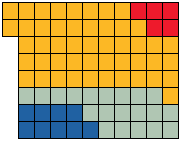
Composition of Cornwall Council, 2017.svg 360 × 185; 6 KB
-
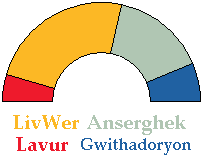
Cornwall Council 2009 pie chart.svg 700 × 700; 6 KB
-
Cornwall Council 20mph bus stop poster, Tresillian, Cornwall - March 2024.jpg 3,024 × 4,032; 1.63 MB
-
Cornwall Council composition 2016.svg 360 × 185; 17 KB
-
Cornwall Council composition May 2011.png 584 × 574; 120 KB
-
Cornwall Council composition.png 625 × 625; 6 KB
-
Cornwall Council Electoral Divisions Map.PNG 1,452 × 1,416; 231 KB
-
Cornwall Council political divisions August 2016 map.svg 1,306 × 1,266; 1.69 MB
-
Cornwall Council political divisions December 2013 map.svg 1,224 × 1,187; 1.65 MB
-
Cornwall Council political divisions December 2014 map.svg 1,224 × 1,187; 1.65 MB
-
Cornwall Council political divisions March 2018 map.svg 1,306 × 1,266; 1.71 MB
-
Cornwall Council political divisions May 2017 map.svg 1,306 × 1,266; 1.71 MB
-
Cornwall Council recycling lorry, Fore Street, Probus, Cornwall - August 2023.jpg 3,913 × 2,670; 1.37 MB
-
Cornwall Council vacuum tanker truck, St Ives, Cornwall - February 2023.jpg 4,032 × 3,024; 3.07 MB
-
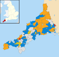
Cornwall electoral division map 2021.svg 1,306 × 1,266; 1.79 MB
-
Cornwall UK local election 2009 map.svg 1,224 × 1,187; 2.06 MB
-
Cornwall UK local election 2013 map.svg 1,224 × 1,187; 1.65 MB
-
Julian German.jpg 683 × 1,023; 98 KB
-
Konsel Kernow 2005.png 181 × 141; 1 KB
-
Konsel.png 203 × 156; 3 KB
-
Parking sign, Smeaton's Pier, St Ives.jpg 4,128 × 2,322; 2.62 MB
-
Register Office, St Austell, Cornwall - July 2023.jpg 4,477 × 2,722; 1.54 MB
-
St Teath and Tintagel electoral division map 2021.svg 1,306 × 1,266; 1.78 MB
-
United Kingdom Cornwall County Council 2021.svg 360 × 185; 6 KB