Attēls:Map of the war in Donbass.svg

Size of this PNG preview of this SVG file: 504 × 600 pikseļi. Citi izmēri: 202 × 240 pikseļi | 403 × 480 pikseļi | 645 × 768 pikseļi | 860 × 1 024 pikseļi | 1 720 × 2 048 pikseļi | 2 270 × 2 702 pikseļi.
Sākotnējais fails (SVG fails, definētais izmērs 2 270 × 2 702 pikseļi, faila izmērs: 2,86 MB)
| Šis fails ir no Vikikrātuves. Tā apraksts no attēla lapas Vikikrātuvē ir parādīts zemāk. Vikikrātuve ir brīvi licencēta failu krātuve. Tu vari tai palīdzēt. |
Kopsavilkums
| Apraksts |
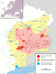
Azərbaycanca: Qırmızı və çəhrayı: Novorossiya ordusunun nəzarəti altında olan şəhərlər və ya sahələr; Narıncı rəngi: uğrunda döyüşlər gedən və ya statusu mübahisəli olan şəhərlər; Mavi və sarı: Ukrayna hökumətinin nəzarəti altında olan şəhərlər və ya sahələr. Català: Vermell i rosa: Les ciutats o zones que es troben sota el control de l'exèrcit de la Nova Rússia; Color taronja: Les ciutats que són objecte de controvèrsia o on hi ha combats; Blau i groc: Les ciutats o zones que estan sota el control del govern ucraïnès. Čeština: Červená a růžová: Města a oblasti, které jsou pod kontrolou armády Novorossiya; Oranžová barva: Města, která jsou sporná, nebo tam, kde je boj; Modré a žluté: Města a oblasti pod kontrolou vlády Ukrajiny. Deutsch: Karte (siehe Aktualisierungsdatum) des Kriegs im Donbass 2014 zwischen den Separatisten des Bundesstaats Neurussland und der ukrainischen Zentralregierung. Sie zeigt die unmittelbaren Einflussgebiete beider Seiten. Gelbe Flächen mit blau eingezeichneten Orten: ehemaliger Einflussbereich der Separatisten; violette Flächen mit rot eingezeichneten Orten: aktueller Herrschaftsbereich der Separatisten. Orangefarbene Orte: aktuell umkämpfte Ortschaften. English: Map of the War in Donbass, a conflict in Eastern Ukraine. It shows areas of fighting, and which sides have de facto control of particular regions.
Territory controlled by the Donetsk People's Republic (DNR) and by the Luhansk People's Republic (LNR)
Cities controlled by DNR and LNR (as well provided from Russian forces)
Territory controlled by Ukrainian government
Cities controlled by Ukrainian government
Cities where there is fighting Español: Rojo y rosa: Las ciudades o zonas que se encuentran bajo el control del ejército de Novorossiya; Naranja: Ciudades en disputa entre Ucrania y Novorossiya, o donde hay enfrentamientos entre Ucrania y el Ejército de Novorossiya; Azul y amarillo: Las ciudades o zonas bajo el control del gobierno ucraniano. Français : Territoire contrôlé par la République populaire de Donetsk (DNR) et par la République populaire de Lougansk (LNR)
Villes contrôlées par les forces séparatistes pro-russes
Territoire contrôlé par l'Ukraine
Villes contrôlées par les forces loyalistes
Territoire disputé / zone de combats Galego: Vermello e rosa: Cidades ou áreas que están baixo o control do Exército da Nova Rusia; Cor laranxa: Cidades en disputa entre a Ucraína e o Exército da Nova Rusia, ou onde hai combates entre a Ucraína e do Exército de Nova Rusia; Azul e amarelo: cidades ou áreas baixo o control do goberno ucraíno. Hrvatski: Crvena i ružičasta: Gradovi ili područja koja su pod kontrolom vojske Novorossiya; Narančasta boja: Gradovi sporne između Ukrajine i Novorossiya, odnosno tamo gdje se bori između Ukrajine i Armije Novorossiya; Plava i žuta: Gradovi ili područja pod ukrajinske državne kontrole. Suomi: Punainen ja pinkki: Kansantasavaltojen liitto Novorossijan hallinnassa olevat alueet ja kaupungit; Oranssi: Kaupungit, joissa tällä hetkellä taistellaan; Sininen ja keltainen: Ukrainan hallituksen hallinnassa olevat alueet ja kaupungit. Tiếng Việt: Bản đồ của chiến trnah Donbass, một giao chiến ở đông Ukraina. Nó hiển thị các vùng chiến đấu và các phái nào có quyền lực trong các khu vực cụ thể.
Lãnh thổ kiểm soát bởi Cộng hòa Nhân dân Donetsk và Cộng hòa Nhân dân Luhansk
Thành phố kiểm soát bởi DNR, LNR và thế lực Nga
Lãnh thổ của chính phủ Ukraina
Thành phố được kiểm soát bởi chính phủ Ukraina
Thành phố nơi có giao chiến Ελληνικά: Κόκκινο και ροζ: Πόλεις και περιοχές που βρίσκονται υπό τον έλεγχο του στρατού του Νοβοροσία? Πορτοκαλί: Πόλεις προσβαλλόμενη μεταξύ της Ουκρανίας και της Νέας Ρωσίας, ή όπου υπάρχει αγωνίζονται μεταξύ της Ουκρανίας και του Στρατού των Νοβοροσία? Μπλε και κίτρινο: Πόλεις ή περιοχές υπό τον έλεγχο της κυβέρνησης της Ουκρανίας. Беларуская: Чырвоны і ружовы: Гарады і раёны, якія знаходзяцца пад кантролем сепаратысцкага арміі новай Расіі; Orange: Гарады, якія аспрэчваюцца ці там, дзе ёсць байцоўскія; Сіні і жоўты: Гарады і раёны, якія пад украінскім дзяржаўным кантролем. Български: Червено и розово: градове или области, които са под контрола на про-руските сили; Оранжево: Оспорвани градове и области; Синьо и жълто: градове или области под контрола на украинското правителство. Русский: Карта боевых действий, которая иллюстрирует война в Донбассе, показывая распределение контроля над территориями. Українська: Війна на сході України: оновлювана мапа бойових дій, яка показує розподіл контролю над територіями. ქართული: წითელი და ვარდისფერი: ქალაქები და ტერიტორიები, რომლებსაც თვითგამოცხადებული დონეცკისა და ლუგანსკის რესპუბლიკები აკონტროლებს; ნარინჯისფერი: ქალაქები სადაც ბრძოლები მიმდინარეობს; ლურჯი და ყვითელი: ქალაქები და ტერიტორიები რომელსაც უკრაინის მთავრობა აკონტროლებს. Հայերեն : Կարմիր եւ վարդագույն: Cities կամ տարածքները, որոնք գտնվում են վերահսկողության տակ բանակի Նոր Ռուսաստան. Orange: Cities, որոնք վիճելի կամ որտեղ կա պայքարում. Կապույտ, դեղին: Cities կամ տարածքները, որոնք գտնվում են Ուկրաինայի կառավարության վերահսկողության. भोजपुरी: লাল এবং গোলাপী: নতুন রাশিয়া সেনা নিয়ন্ত্রণ অধীন যে শহর বা এলাকায়; কমলা রঙ: ইউক্রেন এবং নিউ রাশিয়া, বা ইউক্রেন এবং নতুন রাশিয়া আর্মি মধ্যে আছে যুদ্ধ হয়, যেখানে মধ্যে প্রতিযোগিতা শহর; নীল ও হলুদ: ইউক্রেরিয়ান সরকার নিয়ন্ত্রণ অধীনে শহর বা এলাকায়. हिन्दी : लाल और गुलाबी: नई रूस की सेना के नियंत्रण में हैं कि शहरों या क्षेत्रों; ऑरेंज: यूक्रेन और न्यू रूस के बीच विभाजित शहरों; नई रूस की सेना के खिलाफ यूक्रेन की सेना की लड़ाई; नीले और पीले रंग: यूक्रेनी सरकार के नियंत्रण में शहरों या क्षेत्रों. 한국어: 레드와 핑크 : 새로운 러시아의 군대의 통제하에 도시 또는 지역; 오렌지 색상 : 경쟁하거나 싸움이되는 경우 도시; 파란색과 노란색 : 우크라이나 정부의 통제하에 도시 또는 지역. 中文: 红色和粉红色:城市或地区是新俄罗斯的军队的控制之下;橙色:这是有争议的或近期有战斗的城市;蓝色和黄色:乌克兰政府控制下的城市或地区。 עברית : אדום וורוד: ערים או באזורים שנמצאים תחת שליטתו של הצבא של נובורוסיה; כתומות: ערים במחלוקת בין אוקראינה ונובורוסיה, או שבו מתנהל לחימה בין אוקראינה והצבא של נובורוסיה; כחול וצהוב: ערים או באזורים שבשליטת הממשלה האוקראינית. العربية : الأأمر والوردي: المدن أو المناطط التي هي تحت سيطرة الجيش الانفصالي من جديد روسيا. البرتقال: المدن التي يجري المتنازع عليها أو حيث هناك قتال. الأزرق والأصفر: المدن أو المناطق التي هي تحت سيطرة الحكومة الأوكةيا. فارسی : قرمز و صورتی - شهرهای و یا مناطقی که تحت کنترل ارتش "جدید روسیه" می باشد. رنگ نارنجی - شهرهای بین اوکراین و "جدید روسیه" رقابت، و یا که در آن در حال مبارزه بین اوکراین و ارتش "روسیهی جدید" وجود دارد. آبی و زرد - شهرهای و مناطق تحت کنترل دولت اوکراین. |
||
| Datums | 2014. gada 11. augusts, 14:22:35 (first version) | ||
| Avots |
Šis fails tika iegūts no: East Ukraine conflict.png |
||
| Autors | ZomBear, Marktaff | ||
| Citas versijas |
[]
|


|
This file may be updated to reflect new information. If you wish to use a specific version of the file without new updates being mirrored, please upload the required version as a separate file. |
Licence
Es, šī darba autortiesību īpašnieks, publicēju to saskaņā ar šo licenci:
This file is licensed under the Creative Commons Attribution-Share Alike 4.0 International license.
- Jūs varat brīvi:
- koplietot – kopēt, izplatīt un pārraidīt darbu
- remiksēt – pielāgot darbu
- Saskaņā ar šādiem nosacījumiem:
- atsaucoties – Tev ir jānorāda autors, saite uz licenci un to, vai veiktas kādas izmaiņas. To var darīt jebkādā saprātīgā veidā, bet ne tādā, kas norādītu, ka licencētājs atbalsta tevi vai veidu, kā tu izmanto šo darbu.
- nemainot licenci – Ja tu miksē, pārveido vai izmanto materiālu, tev savs devums jāpublicē ar to pašu vai saderīgu licenci kā oriģināls.
Faila hronoloģija
Uzklikšķini uz datums/laiks kolonnā esošās saites, lai apskatītos, kā šis fails izskatījās tad.
| Datums/Laiks | Attēls | Izmēri | Dalībnieks | Komentārs | |
|---|---|---|---|---|---|
| tagadējais | 2024. gada 9. maijs, plkst. 07.59 | 2 270 × 2 702 (2,86 MB) | Physeters | Updates per the ISW | |
| 2023. gada 30. septembris, plkst. 08.37 | 2 125 × 2 532 (2,34 MB) | Hoben7599 | Khromove battle end | ||
| 2023. gada 13. augusts, plkst. 04.37 | 2 125 × 2 532 (2,34 MB) | Physeters | Update per the ISW | ||
| 2023. gada 27. jūnijs, plkst. 22.49 | 2 125 × 2 532 (2,34 MB) | Physeters | Updates per the ISW; make a couple of fixes | ||
| 2023. gada 12. jūnijs, plkst. 04.06 | 2 125 × 2 532 (2,34 MB) | Physeters | Updates per the ISW; add a bunch of villages south of Velyka Novosilka | ||
| 2023. gada 25. marts, plkst. 00.45 | 2 125 × 2 532 (2,32 MB) | Physeters | Updates per the ISW | ||
| 2023. gada 22. janvāris, plkst. 13.15 | 2 125 × 2 532 (2,32 MB) | Physeters | Updates per ISW; add a bunch of settlements | ||
| 2022. gada 12. decembris, plkst. 18.57 | 2 125 × 2 532 (2,21 MB) | Nahabino | Update per ISW | ||
| 2022. gada 6. novembris, plkst. 18.09 | 2 125 × 2 532 (2,25 MB) | Yurii Rassokha | Updated the map, corrected the transliteration | ||
| 2022. gada 23. augusts, plkst. 05.17 | 2 266 × 2 708 (2,16 MB) | Physeters | Brought map up to date since it is still in the main article even though it may be decided in future to revert the map to the pre February 24 situation. | ||
| 2022. gada 1. jūnijs, plkst. 20.50 | 2 266 × 2 708 (2,19 MB) | Boer Koekoek | Reverted to version as of 16:05, 1 June 2022 (UTC) Simply better version, has rivers, cities are more acccurate, More cities on the map, better borders, has names for northern cities in the DPR, way less inconsistencies (DNR doesnt have novobatmukva, Bilhorvka, but does have Svyatohirsk, and many more mistakes) | ||
| 2022. gada 1. jūnijs, plkst. 20.21 | 2 066 × 2 708 (1,97 MB) | Shiro D. Neko | Reverted to version as of 15:31, 1 June 2022 (UTC): not consistently, not consensus, maybe COM:POV | ||
| 2022. gada 1. jūnijs, plkst. 19.05 | 2 266 × 2 708 (2,19 MB) | Nicolay Sidorov | Reverted to version as of 21:11, 31 May 2022 (UTC) Russian names for Russian cities of Donbass, Sloboda Borderland and Novorussia. Ukraine is out there, but is not in russian places | ||
| 2022. gada 1. jūnijs, plkst. 18.31 | 2 066 × 2 708 (1,97 MB) | Dƶoxar | correction | ||
| 2022. gada 1. jūnijs, plkst. 18.29 | 2 066 × 2 708 (1,97 MB) | Dƶoxar | correction | ||
| 2022. gada 1. jūnijs, plkst. 18.15 | 2 066 × 2 708 (1,97 MB) | Dƶoxar | Ukrainian names of cities reverted | ||
| 2022. gada 1. jūnijs, plkst. 00.11 | 2 266 × 2 708 (2,19 MB) | Nicolay Sidorov | update | ||
| 2022. gada 30. maijs, plkst. 18.53 | 2 266 × 2 708 (2,18 MB) | Nicolay Sidorov | update | ||
| 2022. gada 28. maijs, plkst. 21.01 | 2 266 × 2 708 (2,18 MB) | Nicolay Sidorov | ... | ||
| 2022. gada 28. maijs, plkst. 15.42 | 2 266 × 2 708 (2,18 MB) | Nicolay Sidorov | ... | ||
| 2022. gada 25. maijs, plkst. 09.56 | 2 266 × 2 708 (2,18 MB) | Nicolay Sidorov | ... | ||
| 2022. gada 24. maijs, plkst. 16.20 | 2 266 × 2 708 (2,18 MB) | Nicolay Sidorov | update | ||
| 2022. gada 20. maijs, plkst. 22.04 | 2 266 × 2 708 (2,18 MB) | Nicolay Sidorov | update | ||
| 2022. gada 19. maijs, plkst. 22.45 | 2 266 × 2 708 (2,15 MB) | Serafart | mariupol DNR | ||
| 2022. gada 17. maijs, plkst. 06.05 | 2 266 × 2 708 (2,18 MB) | Nicolay Sidorov | ... | ||
| 2022. gada 16. maijs, plkst. 09.29 | 2 266 × 2 708 (2,18 MB) | Nicolay Sidorov | update | ||
| 2022. gada 10. maijs, plkst. 20.03 | 2 266 × 2 708 (2,18 MB) | Nicolay Sidorov | ... | ||
| 2022. gada 7. maijs, plkst. 17.13 | 2 266 × 2 708 (2,18 MB) | Nicolay Sidorov | update | ||
| 2022. gada 18. aprīlis, plkst. 19.03 | 2 066 × 2 708 (2,1 MB) | Shahanshah26 | Updated with Russian capture of Kreminna/Kremennaya | ||
| 2022. gada 7. aprīlis, plkst. 22.21 | 2 066 × 2 708 (2,06 MB) | Nicolay Sidorov | fix | ||
| 2022. gada 5. aprīlis, plkst. 23.44 | 2 066 × 2 708 (2,06 MB) | Nicolay Sidorov | ... | ||
| 2022. gada 4. aprīlis, plkst. 17.04 | 2 066 × 2 708 (2,01 MB) | Nicolay Sidorov | update | ||
| 2022. gada 30. marts, plkst. 23.18 | 2 066 × 2 708 (2,01 MB) | Nicolay Sidorov | fix Izium suburb frontline | ||
| 2022. gada 30. marts, plkst. 12.44 | 2 066 × 2 708 (2,01 MB) | Nicolay Sidorov | fix northern boundary of DPR | ||
| 2022. gada 30. marts, plkst. 09.51 | 2 066 × 2 708 (2 MB) | Nicolay Sidorov | update | ||
| 2022. gada 25. marts, plkst. 02.40 | 2 066 × 2 708 (1,98 MB) | Serafart | 24 mar update. per liveuamap and other sources | ||
| 2022. gada 12. marts, plkst. 04.16 | 2 066 × 2 708 (1,99 MB) | Ajthedogbruh | Reverted to version as of 02:35, 2 March 2022 (UTC) | ||
| 2022. gada 11. marts, plkst. 09.06 | 2 066 × 2 708 (1,86 MB) | AshFox | Reverted to version as of 15:44, 22 February 2022 (UTC) | ||
| 2022. gada 2. marts, plkst. 05.35 | 2 066 × 2 708 (1,99 MB) | Serafart | mariupol encircled | ||
| 2022. gada 1. marts, plkst. 02.30 | 2 066 × 2 708 (1,99 MB) | Serafart | nikolske direction contested | ||
| 2022. gada 28. februāris, plkst. 21.09 | 2 066 × 2 708 (1,99 MB) | Serafart | pushilin was in hranite >> dnr control | ||
| 2022. gada 28. februāris, plkst. 21.05 | 2 066 × 2 708 (1,99 MB) | Serafart | cities of unknown status used to get made orange on this map as well. reflected. dpr forces closer to mariupol | ||
| 2022. gada 28. februāris, plkst. 05.27 | 2 066 × 2 708 (1,99 MB) | Serafart | Berdyansk wouldn't fit just "DNR and LNR" | ||
| 2022. gada 28. februāris, plkst. 05.25 | 2 066 × 2 708 (1,99 MB) | Serafart | + Berdyansk. White areas are intended for areas of unclear control, so added some white areas | ||
| 2022. gada 27. februāris, plkst. 23.00 | 2 066 × 2 708 (1,99 MB) | Serafart | update 27 feb 2022 | ||
| 2022. gada 22. februāris, plkst. 18.44 | 2 066 × 2 708 (1,86 MB) | SenseiAC | Reverted to version as of 17:59, 17 February 2022 (UTC) No reason to remov the legend | ||
| 2022. gada 20. februāris, plkst. 14.06 | 2 066 × 2 708 (1,98 MB) | The RedBurn | Without legend text (only the scale and copyright) | ||
| 2022. gada 17. februāris, plkst. 20.59 | 2 066 × 2 708 (1,86 MB) | Pabythdali | Shelling in Stanytsia Luhanska | ||
| 2021. gada 6. decembris, plkst. 22.52 | 2 066 × 2 708 (1,86 MB) | Brobt | Should be fine now. | ||
| 2021. gada 6. decembris, plkst. 22.50 | 2 066 × 2 708 (1,86 MB) | Brobt | Self-revert, I seemed to have accidentally gotten rid of the red layer | ||
| 2021. gada 6. decembris, plkst. 22.49 | 2 066 × 2 708 (1,86 MB) | Brobt | Marinka and Avdiivka skirmishes | ||
| 2021. gada 4. novembris, plkst. 19.52 | 2 066 × 2 708 (1,86 MB) | Brobt | Nothing's been happening in Pikuzy for 4 years | ||
| 2021. gada 27. oktobris, plkst. 21.08 | 2 066 × 2 708 (1,86 MB) | Brobt | Likewise, the suburbs around Horlivka have been out of rebel hands for a WHILE. | ||
| 2021. gada 27. oktobris, plkst. 20.54 | 2 066 × 2 708 (1,86 MB) | Brobt | Also, Marinka has been under Ukrainian control since mid-2015. Whoever upkept this map really didn't try. | ||
| 2021. gada 27. oktobris, plkst. 20.36 | 2 190 × 2 707 (1,86 MB) | Brobt | Staromar'ivka seized by Ukraine military | ||
| 2020. gada 3. jūnijs, plkst. 21.58 | 2 048 × 2 701 (2,2 MB) | Viiictorrr | minor changes to correct names | ||
| 2020. gada 2. jūnijs, plkst. 15.31 | 2 048 × 2 701 (2,2 MB) | Viiictorrr | corrected some names of Ukrainian cities to current status | ||
| 2017. gada 26. jūnijs, plkst. 23.21 | 2 048 × 2 701 (2,2 MB) | EkoGraf | No fighting inside the city itself | ||
| 2017. gada 2. februāris, plkst. 03.40 | 2 048 × 2 701 (2,2 MB) | Serafart | Fighting in Avdiivka | ||
| 2016. gada 14. jūlijs, plkst. 02.43 | 2 048 × 2 701 (2,2 MB) | Serafart | minor changes to a few towns http://militarymaps.info/ | ||
| 2016. gada 24. maijs, plkst. 19.31 | 2 048 × 2 701 (2,2 MB) | Bogomolov.PL | spelling in the legend (Ukranian → Ukrainian) | ||
| 2016. gada 12. janvāris, plkst. 11.08 | 2 048 × 2 701 (2,2 MB) | Chocofrito | Shyrokyne and Kominternove - http://militarymaps.info/ | ||
| 2015. gada 20. novembris, plkst. 07.35 | 2 048 × 2 701 (2,2 MB) | Spesh531 | fixing color of some towns | ||
| 2015. gada 20. novembris, plkst. 07.32 | 2 048 × 2 701 (2,2 MB) | Spesh531 | http://liveuamap.com/ November 19 2015 | ||
| 2015. gada 24. februāris, plkst. 21.42 | 2 048 × 2 701 (2,2 MB) | HCPUNXKID | Pavlopil, per http://www.newsweek.com/ukrainian-separatists-take-two-towns-push-mariupol-309068 | ||
| 2015. gada 24. februāris, plkst. 02.27 | 2 048 × 2 701 (2,2 MB) | HCPUNXKID | Updated per http://militarymaps.info/ & http://en.interfax.com.ua/news/general/252015.html | ||
| 2015. gada 20. februāris, plkst. 19.38 | 2 048 × 2 701 (2,2 MB) | HCPUNXKID | Corrected yellow zone position wich was misplaced | ||
| 2015. gada 20. februāris, plkst. 02.45 | 2 048 × 2 701 (2,2 MB) | HCPUNXKID | Updated per comparison of http://militarymaps.info/ & http://liveuamap.com/ | ||
| 2014. gada 26. novembris, plkst. 02.29 | 2 048 × 2 701 (2,2 MB) | HCPUNXKID | Updated per http://militarymaps.info/ & http://liveuamap.com/ | ||
| 2014. gada 26. novembris, plkst. 01.40 | 2 048 × 2 701 (2,2 MB) | Leftcry | small update | ||
| 2014. gada 24. novembris, plkst. 06.40 | 2 048 × 2 701 (2,2 MB) | Mondolkiri1 | Update according to militarymaps.com. Like Donetsk which is under shelling from Ukrainian forces but is essentially under rebel forces, vice-versa applies to Mariupol | ||
| 2014. gada 21. novembris, plkst. 20.02 | 2 048 × 2 701 (2,2 MB) | HCPUNXKID | Per http://www.rnbo.gov.ua/files/2014/21-11.jpg | ||
| 2014. gada 17. novembris, plkst. 02.43 | 2 048 × 2 701 (2,2 MB) | HCPUNXKID | Updated per http://militarymaps.info/, http://liveuamap.com/ | ||
| 2014. gada 13. novembris, plkst. 21.02 | 2 048 × 2 701 (2,2 MB) | HCPUNXKID | Updated per http://militarymaps.info/, http://liveuamap.com/ | ||
| 2014. gada 9. novembris, plkst. 08.49 | 2 048 × 2 701 (2,2 MB) | Leftcry | Fix | ||
| 2014. gada 9. novembris, plkst. 07.24 | 2 048 × 2 701 (2,2 MB) | Mondolkiri1 | Updated version according to militarymaps | ||
| 2014. gada 9. novembris, plkst. 07.24 | 2 048 × 2 701 (2,2 MB) | Mondolkiri1 | Updated version according to militarymaps | ||
| 2014. gada 6. novembris, plkst. 17.59 | 2 048 × 2 701 (2,2 MB) | HCPUNXKID | Updated per http://militarymaps.info/ | ||
| 2014. gada 5. novembris, plkst. 19.24 | 2 048 × 2 701 (2,2 MB) | HCPUNXKID | Updated per http://militarymaps.info/ | ||
| 2014. gada 5. novembris, plkst. 02.30 | 2 048 × 2 701 (2,2 MB) | HCPUNXKID | Updated per http://militarymaps.info/ & http://www.rnbo.gov.ua/files/2014/04-11.jpg | ||
| 2014. gada 2. novembris, plkst. 21.25 | 2 048 × 2 701 (2,2 MB) | Leftcry | Minor fix | ||
| 2014. gada 1. novembris, plkst. 03.26 | 2 048 × 2 701 (2,2 MB) | HCPUNXKID | Updated per militarymaps.info & http://www.rnbo.gov.ua/files/2014/31-10.jpg | ||
| 2014. gada 31. oktobris, plkst. 02.44 | 2 048 × 2 701 (2,19 MB) | HCPUNXKID | Updated per http://militarymaps.info/ & http://www.rnbo.gov.ua/files/2014/30-10_eng.jpg | ||
| 2014. gada 23. oktobris, plkst. 01.47 | 2 048 × 2 701 (2,19 MB) | HCPUNXKID | Sources: http://militarymaps.info/ & http://www.rnbo.gov.ua/files/2014/22-10_eng.jpg | ||
| 2014. gada 21. oktobris, plkst. 01.19 | 2 048 × 2 701 (2,19 MB) | Mondolkiri1 | Source: http://militarymaps.info/ | ||
| 2014. gada 19. oktobris, plkst. 23.40 | 2 048 × 2 701 (2,19 MB) | Arbutus the tree | Reverted to version as of 16:12, 17 October 2014 RIA NOVOSTI reported that ukrainian forces control parts of the airport, and no reliable sources were provided confirmin the fall of it | ||
| 2014. gada 19. oktobris, plkst. 05.36 | 2 048 × 2 701 (2,19 MB) | Mondolkiri1 | Source - http://militarymaps.info/ | ||
| 2014. gada 17. oktobris, plkst. 19.12 | 2 048 × 2 701 (2,19 MB) | Mondolkiri1 | Source: http://militarymaps.info/ | ||
| 2014. gada 15. oktobris, plkst. 17.21 | 2 048 × 2 701 (2,19 MB) | Mondolkiri1 | Source: http://militarymaps.info/ | ||
| 2014. gada 13. oktobris, plkst. 20.22 | 2 048 × 2 701 (2,19 MB) | Mondolkiri1 | Source: http://militarymaps.info/ | ||
| 2014. gada 13. oktobris, plkst. 01.48 | 2 048 × 2 701 (2,19 MB) | HCPUNXKID | Updated map per comparison of http://militarymaps.info/ & http://liveuamap.com/, added Spartak town | ||
| 2014. gada 11. oktobris, plkst. 21.55 | 2 048 × 2 701 (2,19 MB) | Mondolkiri1 | Source: http://militarymaps.info/ | ||
| 2014. gada 11. oktobris, plkst. 12.47 | 2 048 × 2 701 (2,19 MB) | Mondolkiri1 | Sources: http://militarymaps.info/ ; http://podrobnosti.ua/accidents/2014/10/09/997180.html | ||
| 2014. gada 9. oktobris, plkst. 18.15 | 2 048 × 2 701 (2,19 MB) | Mondolkiri1 | Corrected Novotroitske and Mar'inka: source - http://militarymaps.info/ | ||
| 2014. gada 9. oktobris, plkst. 03.45 | 2 048 × 2 701 (2,19 MB) | Mondolkiri1 | Small correction in the pink zone and added Trudivs'ke - http://militarymaps.info/ | ||
| 2014. gada 9. oktobris, plkst. 02.49 | 2 048 × 2 701 (2,19 MB) | Mondolkiri1 | Update. Sources: http://militarymaps.info/ and others in my talk page | ||
| 2014. gada 7. oktobris, plkst. 20.46 | 2 048 × 2 701 (2,19 MB) | Mondolkiri1 | Corrected Valuiske - orange: http://militarymaps.info/ | ||
| 2014. gada 7. oktobris, plkst. 19.05 | 2 048 × 2 701 (2,19 MB) | Mondolkiri1 | Update: source: http://militarymaps.info/ | ||
| 2014. gada 7. oktobris, plkst. 12.51 | 2 048 × 2 701 (2,18 MB) | Hanibal911 | self revert | ||
| 2014. gada 7. oktobris, plkst. 12.41 | 2 048 × 2 701 (2,18 MB) | Hanibal911 | return to correct version firstly Vuhlehir'sk seized by rebels http://society.lb.ua/accidents/2014/09/20/280048_sili_ato_ushli_naselennih_punktov.html http://mediarnbo.org/wp-content/uploads/2014/10/7ff230c-sbu0.jpg |
Faila lietojums
Šo failu izmanto šajās 4 lapās:
Globālais faila lietojums
Šīs Vikipēdijas izmanto šo failu:
- Izmantojums ar.wikipedia.org
- Izmantojums az.wikipedia.org
- Izmantojums be-tarask.wikipedia.org
- Izmantojums be.wikipedia.org
- Izmantojums bg.wikipedia.org
- Izmantojums bn.wikipedia.org
- Izmantojums ca.wikipedia.org
- Izmantojums ckb.wikipedia.org
- Izmantojums cs.wikipedia.org
- Izmantojums da.wikipedia.org
- Izmantojums de.wikipedia.org
- Izmantojums el.wikipedia.org
- Izmantojums en.wikipedia.org
- Talk:Novorossiya (confederation)/Archive 4
- Civil–military administrations (Ukraine)
- User:Pietadè/DonbasWarTimelines
- Timeline of the war in Donbas (2015)
- Timeline of the war in Donbas (2016)
- Timeline of the war in Donbas (2020)
- Timeline of the war in Donbas (2017)
- Timeline of the war in Donbas (2018)
- Timeline of the war in Donbas (2022)
- Russian invasion of Ukraine
- Timeline of the war in Donbas (2019)
- User:MLBFanAdrien/sandbox
- User talk:Physeters//Archives/2023
- User:Falcaorib/Ukraine
- Izmantojums eo.wikipedia.org
- Izmantojums es.wikipedia.org
- Izmantojums es.wikinews.org
- Izmantojums et.wikipedia.org
- Donbassi sõja kronoloogia (2015. aasta jaanuar–märts)
- Donbassi sõja kronoloogia (2015. aasta aprill–juuni)
- Donbassi sõja kronoloogia (2015. aasta juuli–september)
- Donbassi sõja kronoloogia (2015. aasta oktoober–detsember)
- Donbassi sõja kronoloogia (2016. aasta jaanuar–märts)
- Donbassi sõja kronoloogia (2016. aasta aprill–juuni)
Skatīt šī faila pilno globālo izmantojumu.