Ninety Mile Beach, Victoria: Difference between revisions
No edit summary |
copy edits. two references added. |
||
| Line 1: | Line 1: | ||
{{refimprove|date=August 2007}} |
{{refimprove|date=August 2007}} |
||
[[Image:90mile beach 147.41000E 38.24102S.jpg|thumb|right|200px|False colour [[NASA]] [[landsat]] image of Ninety Mile Beach and the Gippsland Lakes]] |
[[Image:90mile beach 147.41000E 38.24102S.jpg|thumb|right|200px|False colour [[NASA]] [[landsat]] image of Ninety Mile Beach and the Gippsland Lakes]] |
||
The '''Ninety Mile [[Beach]]''' is a sandy stretch of south-eastern coastline of [[Victoria, Australia|Victoria]], [[Australia]] along the [[Gippsland Lakes]] region of [[East Gippsland]] on [[Bass Strait]]. The beach is just over {{convert|151|km|mi}} long running north-eastward from a spit near [[Port Albert, Victoria|Port Albert]] to the man-made channel at [[Lakes Entrance]]. The beach is located |
The '''Ninety Mile [[Beach]]''' is a sandy stretch of south-eastern coastline of [[Victoria, Australia|Victoria]], [[Australia]] along the [[Gippsland Lakes]] region of [[East Gippsland]] on [[Bass Strait]]. The beach is just over {{convert|151|km|mi}} long running north-eastward from a spit near [[Port Albert, Victoria|Port Albert]] to the man-made channel at [[Lakes Entrance]]. The beach is located about {{convert|260|km|mi}} from Melbourne <ref>{{cite web |url=http://www.australia.com/explore/icons/gippsland/vic-90-mile-beach.aspx |title=Ninety Mile Beach, Victoria |author=<!--Staff writer(s); no by-line.--> |date=2012 |work=web page |publisher=Tourism Australia |accessdate=15 December 2012}}</ref>and can be reached from the [[South Gippsland Highway]] passing the coastal towns of [[McLoughlins Beach, Australia|McLoughlins Beach]], [[Woodside, Victoria|Woodside]], [[Seaspray]], [[Golden Beach, Victoria|Golden Beach]], and [[Loch Sport]]. |
||
Behind the beach are long sandy dunes that separate various lakes and lagoons from the ocean. In the northern section, the beach runs along a sandbar on what amounts to a series of tidal islands. Behind this are several large lakes and numerous shallow littoral lagoons. The three main lakes are Lake King, Lake Victoria and Lake Wellington. The area comprises [[The Lakes National Park]]. |
|||
During mating season some species of shark, including the famous Great White Shark gather in the shallow waters along the beach to breed |
During mating season some species of shark, including the famous Great White Shark gather in the shallow waters along the beach to breed. Signs are put up to advise visitors of this. The beach's length ensures that the waves break too close to the beach for good [[surfing]], and there are strong [[rip current]]s and cross-currents that make conditions rather hazardous. The local authorities recommend that anyone who wishes to swim should do so at Woodside, Seaspray and Lakes Entrance, which have [[life saving]] beach patrols during the summer season. The three lakes have different coloured water depending on their surrounding conditions. One has brown water from the tannins that leach from the trees and dead leaves that drop onto the water, another has crystal clear water with a blue tint an gets very dark as it becomes deeper in the middle. The lakes all have water that is very rich in natural minerals and is extremely clean as the banks and lake beds are pure sand. People who regularly visit the lakes exfoliate their skin by rubbing it with the fine golden sand<ref>{{cite web |url=http://www.visitvictoria.com/Regions/Gippsland/Activities-and-attractions/Nature-and-wildlife/National-parks-and-reserves/Ninety-Mile-Beach.aspx |title=Gippsland Ninety Mile Beach |author=<!--Staff writer(s); no by-line.--> |date= |work=web page |publisher=Melbourne & Victoria |accessdate=15 December 2012}}</ref> then rinsing with the crystal clear water. |
||
<gallery> |
<gallery> |
||
| Line 13: | Line 13: | ||
</gallery> |
</gallery> |
||
The beach |
The beach has white sand, with crashing waves and a natural bush environment that is habitat to wild dingoes, birds and other small burrowing mammals. It is part of the [[Ninety Mile Beach Marine National Park]], which covers 2,750 hectares and {{convert|5|km|mi}} of coastline, {{convert|30|km|mi}} south of [[Sale, Victoria|Sale]].<ref>[http://www.parkweb.vic.gov.au/1park_display.cfm?park=263 Parks Victoria]</ref> There are basic camping facilities within the park at Emu Bight, as well as accommodation at Seaspray and Lakes Entrance. |
||
[[Rotamah Island]], which is part of the Lakes National Park, has a large bird observatory, and can be visited by boat from [[Paynesville, Victoria|Paynesville]], about {{convert|6|km|mi}} away. |
[[Rotamah Island]], which is part of the Lakes National Park, has a large bird observatory, and can be visited by boat from [[Paynesville, Victoria|Paynesville]], about {{convert|6|km|mi}} away. |
||
Revision as of 08:00, 15 December 2012
This article needs additional citations for verification. (August 2007) |

The Ninety Mile Beach is a sandy stretch of south-eastern coastline of Victoria, Australia along the Gippsland Lakes region of East Gippsland on Bass Strait. The beach is just over 151 kilometres (94 mi) long running north-eastward from a spit near Port Albert to the man-made channel at Lakes Entrance. The beach is located about 260 kilometres (160 mi) from Melbourne [1]and can be reached from the South Gippsland Highway passing the coastal towns of McLoughlins Beach, Woodside, Seaspray, Golden Beach, and Loch Sport.
Behind the beach are long sandy dunes that separate various lakes and lagoons from the ocean. In the northern section, the beach runs along a sandbar on what amounts to a series of tidal islands. Behind this are several large lakes and numerous shallow littoral lagoons. The three main lakes are Lake King, Lake Victoria and Lake Wellington. The area comprises The Lakes National Park.
During mating season some species of shark, including the famous Great White Shark gather in the shallow waters along the beach to breed. Signs are put up to advise visitors of this. The beach's length ensures that the waves break too close to the beach for good surfing, and there are strong rip currents and cross-currents that make conditions rather hazardous. The local authorities recommend that anyone who wishes to swim should do so at Woodside, Seaspray and Lakes Entrance, which have life saving beach patrols during the summer season. The three lakes have different coloured water depending on their surrounding conditions. One has brown water from the tannins that leach from the trees and dead leaves that drop onto the water, another has crystal clear water with a blue tint an gets very dark as it becomes deeper in the middle. The lakes all have water that is very rich in natural minerals and is extremely clean as the banks and lake beds are pure sand. People who regularly visit the lakes exfoliate their skin by rubbing it with the fine golden sand[2] then rinsing with the crystal clear water.
-
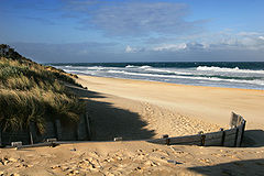
Western edge of 90 Mile Beach
-
90 Mile beach
-
90 Mile beach


The beach has white sand, with crashing waves and a natural bush environment that is habitat to wild dingoes, birds and other small burrowing mammals. It is part of the Ninety Mile Beach Marine National Park, which covers 2,750 hectares and 5 kilometres (3.1 mi) of coastline, 30 kilometres (19 mi) south of Sale.[3] There are basic camping facilities within the park at Emu Bight, as well as accommodation at Seaspray and Lakes Entrance.
Rotamah Island, which is part of the Lakes National Park, has a large bird observatory, and can be visited by boat from Paynesville, about 6 kilometres (3.7 mi) away.
The beach is believed to be the third longest uninterrupted beach in the world, behind Praia do Cassino on the Brazilian southern coast and Padre Island on the US Gulf Coast.
Wild horses were introduced to the park after the islands were explored to help eat and trample down small areas of bush so it could be more easily explored but they were left unchecked and their numbers quickly increased. Their large numbers grew and over time started to caused concern as environmental damage became an issue, but once the park was established as a national heritage the horses were rounded up and transported back across to the mainland.
38°18′08″S 147°17′15″E / 38.3022°S 147.2875°E
References
- ^ "Ninety Mile Beach, Victoria". web page. Tourism Australia. 2012. Retrieved 15 December 2012.
- ^ "Gippsland Ninety Mile Beach". web page. Melbourne & Victoria. Retrieved 15 December 2012.
- ^ Parks Victoria
This article about a location in Gippsland (region) is a stub. You can help Wikipedia by expanding it. |